 CRITICAL FIRE WEATHER CONDITIONS ARE EXPECTED TODAY AND ON SUNDAY... .An approaching upper level system will create stronger west to southwest winds Saturday and Sunday afternoons. Winds look to become gusty in the higher terrain locations as stronger winds aloft move over the area, especially over the Gila Region and Sacramento Mountains. Afternoon humidity values will remain in the single digits through the weekend as well, with overnight humidity recoveries struggling to make it over 30%. A very dry spring has led to extremely dry fuels over much of southern New Mexico and far west Texas. These critical fire weather conditions are expected to persist through the holiday weekend; with winds strengthening in the afternoon hours, afternoon humidity values remaining extremely dry, and overnight humidity recoveries hardly reaching 30%. Similar conditions are expected on Monday except the winds will be slightly weaker than they are this weekend.
RED FLAG WARNING REMAINS IN EFFECT FROM 11 AM THIS MORNING TO
8 PM MDT THIS EVENING FOR LOW HUMIDITY AND STRONG WINDS FOR FIRE
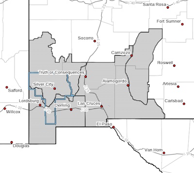
WEATHER ZONES 110, 111, 112, AND 113... ...RED FLAG WARNING IN
EFFECT FROM 10 AM TO 9 PM MDT SUNDAY FOR LOW HUMIDITY AND STRONG
WINDS FOR FIRE WEATHER ZONES 110, 111, 112, AND 113... ...FIRE
WEATHER WATCH IN EFFECT FROM MONDAY AFTERNOON THROUGH MONDAY
EVENING FOR LOW HUMIDITY AND STRONG WINDS FOR FIRE WEATHER ZONES
110, 111, 112, AND 113...
The National Weather Service in El Paso Tx/Santa Teresa has
issued a Red Flag Warning, which is in effect from 10 AM to 9 PM
MDT Sunday. a Fire Weather Watch has also been issued. This Fire
Weather Watch is in effect from Monday afternoon through Monday
evening. The Fire Weather Watch is no longer in effect.
* WIND...Southwest winds of 20 to 30 mph with gusts up to 40
mph. Potentially stronger gusts in higher terrain areas.
* HUMIDITY...5 to 10%.
* IMPACTS...Any fires that develop will likely spread rapidly.
Outdoor burning is not recommended. Please check with the
local agencies for updated burn ban information.
PRECAUTIONARY/PREPAREDNESS ACTIONS...
A Red Flag Warning means that critical fire weather conditions
are either occurring now, or will shortly. A combination of
strong winds, low relative humidity, and warm temperatures can
contribute to extreme fire behavior.
A Fire Weather Watch means that critical fire weather conditions
are forecast to occur. Listen for later forecasts and possible
Red Flag Warnings.