 Southwest Desert/Mimbres Basin NM-
Southwest Desert/Lower Gila River Valley NM-
729 PM MDT Thu Jun 30 2022
...A strong thunderstorm will impact portions of south central Grant,
western Luna and central Hidalgo Counties through 10:30PM MDT...
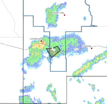
At 729 PM MDT, Doppler radar was tracking a strong thunderstorm 5
miles north of Separ. This storm was nearly stationary.
HAZARD...Winds in excess of 40 mph and penny size hail.
SOURCE...Radar indicated.
IMPACT...Gusty winds could knock down tree limbs and blow around
unsecured objects. Minor damage to outdoor objects is
possible.
Locations impacted include...
Separ.
This includes Interstate 10 in New Mexico between mile markers 33 and
57.
PRECAUTIONARY/PREPAREDNESS ACTIONS...
If outdoors, consider seeking shelter inside a building.
Torrential rainfall is also occurring with this storm and may lead to
localized flooding. Do not drive your vehicle through flooded
roadways.
Frequent cloud to ground lightning is occurring with this storm.
Lightning can strike 10 miles away from a thunderstorm. Seek a safe
shelter inside a building or vehicle.
This storm may intensify, so be certain to monitor local radio
stations and available television stations for additional information
and possible warnings from the National Weather Service.