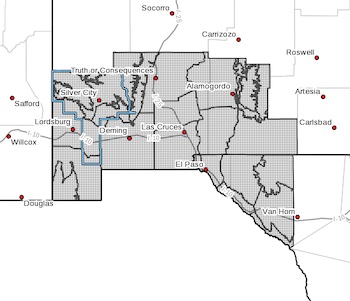
...FLOOD WATCH IN EFFECT FROM FRIDAY EVENING THROUGH LATE SATURDAY
NIGHT...
* WHAT...Flash flooding caused by excessive rainfall is possible.
* WHERE...Portions of New Mexico and southwest Texas, including the
following areas, in New Mexico, Central Tularosa Basin, East
Slopes Sacramento Mountains Below 7500 Feet, Eastern Black Range
Foothills, Lowlands of the Bootheel, Northern Dona Ana County,
Otero Mesa, Sacramento Mountains Above 7500 Feet, Sierra County
Lakes, Southern Dona Ana County/Mesilla Valley, Southern Gila
Foothills/Mimbres Valley, Southern Gila Highlands/Black Range,
Southern Tularosa Basin, Southwest Desert/Lower Gila River Valley,
Southwest Desert/Mimbres Basin, Uplands of the Bootheel, Upper
Gila River Valley and West Slopes Sacramento Mountains Below 7500
Feet. In southwest Texas, Eastern/Central El Paso County, Northern
Hudspeth Highlands/Hueco Mountains, Rio Grande Valley of Eastern
El Paso/Western Hudspeth Counties, Rio Grande Valley of Eastern
Hudspeth County, Salt Basin, Southern Hudspeth Highlands and
Western El Paso County.
* WHEN...From Friday evening through late Saturday night.
* IMPACTS...Excessive runoff may result in flooding of rivers,
creeks, streams, and other low-lying and flood-prone locations.
Flooding may occur in poor drainage and urban areas. Low-water
crossings may be flooded. Storm drains and ditches may become
clogged with debris. Extensive street flooding and flooding of
creeks and rivers are possible.
* ADDITIONAL DETAILS...
- Moist ground from recent rains will allow for quick runoff of
any additional moderate or heavy rain, resulting in flash
flooding and possible flooding of area rivers.
- http://www.weather.gov/safety/flood