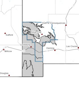
 Upper Gila River Valley-Southern Gila Foothills/Mimbres Valley-
Southwest Desert/Lower Gila River Valley-Lowlands of the Bootheel-
Uplands of the Bootheel-
Including the cities of Cliff, Buckhorn, Gila Hot Springs,
Mule Creek, Mimbres, Hurley, Faywood, Grant County Airport,
Lordsburg, Red Rock, Virden, Antelope Wells, Animas, Hachita,
and Cloverdale
542 AM MST Tue Feb 14 2023
...WINTER STORM WATCH IN EFFECT FROM THIS EVENING THROUGH
WEDNESDAY AFTERNOON...
* WHAT...Heavy snow possible. Total snow accumulations of 2 to 4
inches possible.
* WHERE...Upper Gila River Valley, Southern Gila
Foothills/Mimbres Valley, Southwest Desert/Lower Gila River
Valley, Lowlands of the Bootheel and Uplands of the Bootheel
Counties.
* WHEN...11 PM MST Tuesday to 5 PM MST Wednesday.
* IMPACTS...Falling snow and strong winds will combine to produce
low visibilities and very difficult travel, especially along
US- 82, US-70, NM-152, NM-15, NM-180, and I-10.
* ADDITIONAL DETAILS...Strong wind gusts of 40 to 60 mph may cause
blowing and drifting, especially in the mountains.
PRECAUTIONARY/PREPAREDNESS ACTIONS...
Monitor the latest forecasts for updates on this situation.