 LOW HUMIDITIES AND GUSTY WINDS LEAD TO CHANCES FOR CRITICAL FIRE WEATHER THURSDAY AFTERNOON...
311 PM MDT Tue Apr 11 2023
...FIRE WEATHER WATCH IN EFFECT FROM THURSDAY AFTERNOON THROUGH
THURSDAY EVENING FOR LOW HUMIDITIES AND GUSTY WINDS IN FIRE
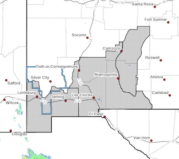
WEATHER ZONES 111, 112, AND 113...
The National Weather Service in El Paso Tx/Santa Teresa has
issued a Fire Weather Watch, which is in effect from Thursday
afternoon through Thursday evening.
* AFFECTED AREA...Fire weather zone 111. Fire weather zone
112.Fire weather zone 113.
* WIND... Potential southwest winds of 20 to 25 mph with gusts of
30 mph in lowlands and 25 to 30 mph in highlands with gusts of
40 mph.
* HUMIDITY...Minimum humidity values from 7 to 13 percent during
strongest winds.
* HIGHEST THREAT...is located in the New Mexico Bootheel.
* IMPACTS...any fires that develop will likely spread rapidly.
Outdoor burning is not recommended.
PRECAUTIONARY/PREPAREDNESS ACTIONS...
A Fire Weather Watch means that critical fire weather conditions
are forecast to occur. Listen for later forecasts and possible
Red Flag Warnings.