 RED FLAG WARNING IN EFFECT ON TUESDAY AFTERNOON AND EVENING FOR THE LOWLANDS OF SOUTHWEST AND SOUTH CENTRAL NEW MEXICO, AND FAR WEST TEXAS... .The return of westerly winds on Monday will slowly scour the moisture from the last cold front. Warm and drier air moves back to southern New Mexico and far west Texas bringing elevated to critical fire weather conditions on Tuesday. Wind speeds will go up on Tuesday afternoon with the development of a surface low in northeastern New Mexico. Winds will be from the west around 20-25 mph with gusts up to 35 mph. Minimum relative humidity will remain in the 5-15 percent range for the lowlands, while the mountains remain around 15 to 25%.
...RED FLAG WARNING IN EFFECT FROM 1 PM TO 8 PM IN EFFECT FROM TUESDAY AFTERNOON THROUGH TUESDAY EVENING FOR WINDY CONDITIONS AND LOW RELATIVE HUMIDITY
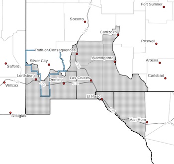
FOR FIRE WEATHER ZONES 055, 056, 111, AND 112...
The National Weather Service in El Paso Tx/Santa Teresa has
issued a Red Flag Warning, which is in effect from Tuesday
afternoon through Tuesday evening.
* AFFECTED AREA...Fire weather zones 111, 112, 055 and 056 this
includes the lowlands of southwest and south-central New Mexico,
and all of far west Texas.
* WIND...west winds 20-25 mph with gusts up to 35 mph.
* HUMIDITY...5-15 percent.
* IMPACTS...any fires that develop will likely spread rapidly.
Outdoor burning is not recommended.
PRECAUTIONARY/PREPAREDNESS ACTIONS...
A Fire Weather Watch means that critical fire weather conditions
are forecast to occur. Listen for later forecasts and possible
Red Flag Warnings.