RED FLAG WARNING IN EFFECT FOR WEDNESDAY AFTERNOON AND EVENING FOR SOUTHWEST AND SOUTH CENTRAL NEW MEXICO... .The region continues in an extended period of warm and dry conditions, as deep southwest flow delivers breezy afternoons. As such, fuels are continuing to dry. On Wednesday a Pacific low will eject across the Four Corners Region, tightening pressure gradients and inducing surface troughing. This will increase wind speeds across the area on Wednesday. A windy afternoon and evening will elevate fire weather conditions to critical. The probability for new wildfire starts and large growth of any existing fires will be increased. Winds will decrease for the end of the week, but RH's will remain low. Relief is possible by Saturday as moisture looks to move in from the east to raise relative humditiy, and bring scattered rain showers.
...RED FLAG WARNING IN EFFECT FROM NOON TO 9 PM MDT WEDNESDAY FOR
STRONG WINDS AND LOW RELATIVE HUMIDITY...
The National Weather Service in El Paso Tx/Santa Teresa has
issued a Red Flag Warning, which is in effect from noon to 9 PM
MDT Wednesday. The Fire Weather Watch is no longer in effect.
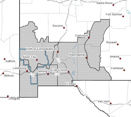
* AFFECTED AREA...In Southern New Mexico this includes fire
weather zones 110, 111, 112, and 113. These zones include the
Gila Region and Southwest mountains, the Southwest and South
Central Deserts, and the Sacramento mountains and surrounding
lowlands.
* WIND...Southwest winds of 20 to 30 mph with gusts 35 to 45
mph.
* HUMIDITY...Minimum relative humidity of 5 to 9 percent over
thelowlands and 8-14 percent over area mountains.
* IMPACTS...Any fires that develop will likely spread rapidly.
Outdoor burning is not recommended.
PRECAUTIONARY/PREPAREDNESS ACTIONS...
A Red Flag Warning means that critical fire weather conditions
are either occurring now, or will shortly. A combination of
strong winds, low relative humidity, and warm temperatures can
contribute to extreme fire behavior.