 [Editor's Note: Other than a slight difference in the map, I don't know what the difference is with the Red Flag Warning that was updated this morning earlier.]
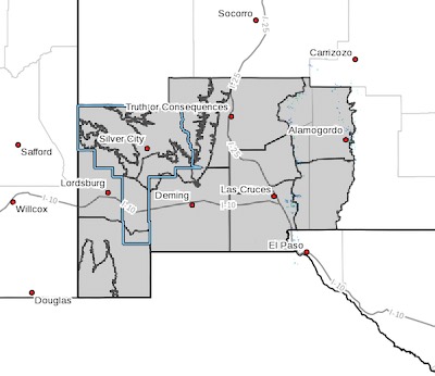
Upper Gila River Valley-Southern Gila Highlands/Black Range-
Southern Gila Foothills/Mimbres Valley-
Southwest Desert/Lower Gila River Valley-Lowlands of the Bootheel-
Uplands of the Bootheel-Southwest Desert/Mimbres Basin-
Eastern Black Range Foothills-Sierra County Lakes-
Northern Dona Ana County-Southern Dona Ana County/Mesilla Valley-
Central Tularosa Basin-Southern Tularosa Basin-
Including the cities of Cliff, Buckhorn, Gila Hot Springs,
Mule Creek, Silver City, Lake Roberts, Kingston, Fort Bayard,
Mimbres, Hurley, Faywood, Grant County Airport, Lordsburg,
Red Rock, Virden, Antelope Wells, Animas, Hachita, Cloverdale,
Deming, Columbus, Hillsboro, Winston, Truth Or Consequences,
Derry, Spaceport, Garfield, Hatch, Radium Springs, Las Cruces,
Vado, Sunland Park, Alamogordo, Tularosa,
White Sands National Park, Chaparral, Orogrande,
and White Sands Range Headquarters
208 PM MDT Tue May 9 2023
...WIND ADVISORY IN EFFECT FROM NOON TO 9 PM MDT WEDNESDAY...
* WHAT...Southwest winds 25 to 35 mph with gusts up to 45 mph
expected.
* WHERE...Portions of south central and southwest New Mexico.
* WHEN...From noon to 9 PM MDT Wednesday.
* IMPACTS...Gusty winds could blow around unsecured objects.
Tree limbs could be blown down and a few power outages may
result.
* ADDITIONAL DETAILS...The strongest winds will occur over the
Gila region and eastern mountain slopes.
* PRECAUTIONARY/PREPAREDNESS ACTIONS...Use extra caution when
driving, especially if operating a high profile vehicle. Secure
outdoor objects.