 Upper Gila River Valley-Southern Gila Foothills/Mimbres Valley-
Southwest Desert/Lower Gila River Valley-Lowlands of the Bootheel-
Uplands of the Bootheel-Southwest Desert/Mimbres Basin-Eastern
Black Range Foothills-Sierra County Lakes-Northern Dona Ana County-Southern Dona Ana County/Mesilla Valley-West Slopes
Sacramento Mountains Below 7500 Feet-Sacramento Mountains Above
7500 Feet-East Slopes Sacramento Mountains Below 7500 Feet-
Central Grant County/Silver City Area-Southern Gila Region
Highlands/Black Range-West Central Tularosa Basin/White Sands-
Including the cities of Mayhill, Sacramento, Las Cruces, Virden,
Sunland Park, White Sands National Park, Hatch, Mimbres, Silver
City, Mule Creek, Kingston, Chaparral, Hillsboro, Grant County
Airport, Deming, Timberon, Lake Roberts, Gila Hot Springs,
Spaceport, Truth Or Consequences, Columbus, White Sands Range
Headquarters, Lordsburg, Cloverdale, Fort Bayard, Mescalero, Red
Rock, Buckhorn, Sunspot, Mountain Park, Cliff, Cloudcroft, Vado,
Hachita, Garfield, Radium Springs, Hurley, Pinon, Apache Summit,
Animas, Faywood, Antelope Wells, Winston, and Derry
216 PM MDT Sat Mar 30 2024
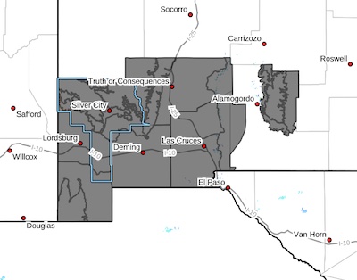
...WIND ADVISORY IN EFFECT FROM NOON TO 8 PM MDT SUNDAY...
* WHAT...Southwest winds 30 to 35 mph with gusts 45 to 55 mph
expected.
* WHERE...Portions of south central and southwest New Mexico.
* WHEN...From noon to 8 PM MDT Sunday.
* IMPACTS...Gusty winds will blow around unsecured objects. Tree
limbs could be blown down and a few power outages may result. Area
of blowing dust are likely to produce areas of limited visibility
resulting in poor traveling conditions.
PRECAUTIONARY/PREPAREDNESS ACTIONS...
Winds this strong can make driving difficult, especially for high
profile vehicles. Watch for areas of blowing dust and limited
visibility. Use extra caution.