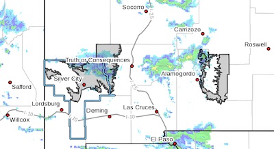
 Winter Storm Continues to Move Through the Borderland Today... .Another winter storm system continues to make its way through the Borderland this afternoon. This system is producing additional snowfall accumulations in the Gila region and Sacramento Mountains. Periods of heavy snow will be likely through the afternoon and early evening hours. Gusty winds and heavier snow showers may cause whiteout conditions at times. All precipitation from this system is expected to come to an end by midnight tonight.
Southern Gila Highlands/Black Range-
West Slopes Sacramento Mountains Below 7500 Feet-
East Slopes Sacramento Mountains Below 7500 Feet-
Including the cities of Silver City, Lake Roberts, Mescalero,
Timberon, and Mayhill
128 PM MST Tue Feb 16 2021
...WINTER WEATHER ADVISORY NOW IN EFFECT UNTIL 11 PM MST THIS
EVENING...
* WHAT...Moderate snow expected. Additional snow accumulations of to
1 to 3 inches through the evening hours. Storm total snow
accumulations will be between 3 to 6 inches across portions of
the Gila and Black Range above 7500 ft, and the west slopes of
the Sacramento mountains. 2 to 4 inches possible across east
slopes of the Sacramento mountains below 7500 ft.
* WHERE...The east slopes of the Sacramento Mountains in south
central New Mexico and the Gila Region including the Black
Range in southwestern New Mexico.
* WHEN...Until 11 PM MST this evening.
* ADDITIONAL DETAILS...The heaviest snow will occur between now
and 5 PM. Gusty winds and heavier snow showers will result in
blowing snow and reduced visibilities at times.
PRECAUTIONARY/PREPAREDNESS ACTIONS...
Roads are likely snow-covered in some areas making driving
hazardous. Slow down and use caution while traveling. The latest
road conditions for the state you are calling from can be obtained
by calling 5 1 1.