 High Fire Danger to Continue This Afternoon and Friday... .Strong southwesterly flow will persist into Friday resulting in winds becoming gusty once again. Expect wind speeds to diminish after sunset tonight, but then increase again by mid to late morning on Friday. Relative humidities will remain around 9-12 percent in most southern NM and far west Texas zones. The exception will be NM110 where RHs will increase slightly to 18-20 percent. Strong winds and dry conditions will continue each day through the weekend into the first of next week.
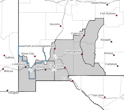
NEW MEXICO FIRE WEATHER ZONE 111
SOUTHWEST DESERTS AND LOWLANDS/LAS CRUCES BLM/GLZ-
NEW MEXICO FIRE WEATHER ZONE 112
SOUTH CENTRAL LOWLANDS AND SOUTHERN RIO GRANDE VALLEY/BLM/GLZ-
NEW MEXICO FIRE WEATHER ZONE 113
CAPITAN AND SACRAMENTO MOUNTAINS/LINCOLN NF/LNZ-
112 PM MST Thu Mar 11 2021
...RED FLAG WARNING REMAINS IN EFFECT UNTIL 7 PM MST THIS EVENING
FOR DRY AND WINDY CONDITIONS FOR FIRE WEATHER ZONES 111, 112, AND
113...
...RED FLAG WARNING IN EFFECT FROM 11 AM TO 7 PM MST
FRIDAY FOR DRY AND WINDY CONDITIONS FOR FIRE WEATHER ZONES 111,
112, AND 113...
The National Weather Service in El Paso Tx/Santa Teresa has
issued a Red Flag Warning, which is in effect from 11 AM to 7 PM
MST Friday.
* AFFECTED AREA...All lowland fire weather zones in southwest and
south central New Mexico (NM111, 112) on Friday, as well as the
Sacramento Mountains (NM113).
* WIND...Sustained winds from the west-southwest at 20 to 25
mph. Wind gusts of 30 to 40 mph.
* HUMIDITY...9 to 14 percent.
* IMPACTS...Any fires that develop will likely spread rapidly.
Outdoor burning is not recommended.
PRECAUTIONARY/PREPAREDNESS ACTIONS...
A Red Flag Warning means that critical fire weather conditions
are either occurring now, or will shortly. A combination of
strong winds, low relative humidity, and warm temperatures can
contribute to extreme fire behavior.