 Critical Fire Weather Conditions Expected on Tuesday... .An upper level system moving through the Rockies will set a westerly flow in southern New Mexico. The resulting surface low over southeastern Colorado will lead to a tight pressure gradient which translates to strong gusty west winds up to 25 mph over southern New Mexico and west Texas. The westerlies bring dry and warm air. Relative humidity drops to the single digits, while temperatures remain about 7 to 12 degrees above normal for the season.
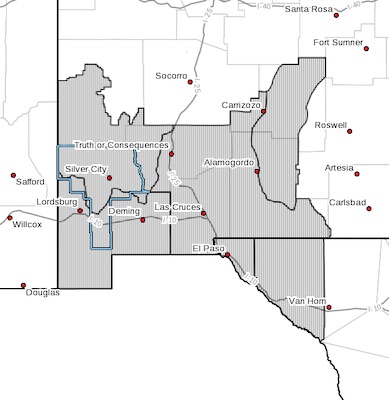
NMZ110>113-TXZ055-056-051200-
/O.NEW.KEPZ.FW.A.0006.210406T1800Z-210407T0200Z/
NEW MEXICO FIRE WEATHER ZONE 110
SOUTHWEST MOUNTAINS/GILA NF/APACHE NF/GLZ-
NEW MEXICO FIRE WEATHER ZONE 111
SOUTHWEST DESERTS AND LOWLANDS/LAS CRUCES BLM/GLZ-
NEW MEXICO FIRE WEATHER ZONE 112
SOUTH CENTRAL LOWLANDS AND SOUTHERN RIO GRANDE VALLEY/BLM/GLZ-NEW MEXICO FIRE WEATHER ZONE 113
CAPITAN AND SACRAMENTO MOUNTAINS/LINCOLN NF/LNZ-
TEXAS FIRE WEATHER ZONE 055
EL PASO COUNTY-TEXAS FIRE WEATHER ZONE 056
HUDSPETH COUNTY-
156 PM MDT Sun Apr 4 2021
RED FLAG WARNING IN EFFECT FROM NOON TO 8 PM MDT TUESDAY FOR
Southwest and South Central New Mexico and Far West Texas...
The National Weather Service in El Paso Tx/Santa Teresa has
issued a Red Flag Warning, which is in effect from noon to 8 PM
MDT Tuesday. The Fire Weather Watch is no longer in effect.
* AFFECTED AREA...New Mexico Fire weather zones 110, 111, 112
and113. Texas Fire weather zones 055 and 056.
* WIND...West winds 25 to 30 MPH.
* HUMIDITY...5 to 10 percent.
* IMPACTS...any fires that develop will likely spread rapidly.
Outdoor burning is not recommended.
PRECAUTIONARY/PREPAREDNESS ACTIONS...
A Red Flag Warning means that critical fire weather conditions
are either occurring now, or will shortly. A combination of
strong winds, low relative humidity, and warm temperatures can
contribute to extreme fire behavior.