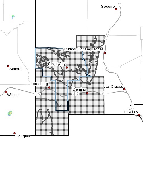
Upper Gila River Valley-Southern Gila Highlands/Black Range-Southern
Gila Foothills/Mimbres Valley-Southwest Desert/Lower Gila River
Valley-Lowlands of the Bootheel-Uplands of the Bootheel-Southwest
Desert/Mimbres Basin-Eastern Black Range Foothills-
Including the cities of Winston, Gila Hot Springs, Animas, Antelope
Wells, Fort Bayard, Hillsboro, Virden, Cloverdale, Columbus, Lake
Roberts, Cliff, Grant County Airport, Hurley, Faywood, Buckhorn,
Mimbres, Lordsburg, Kingston, Deming, Silver City, Mule Creek, Red
Rock, and Hachita
149 PM MDT Tue Aug 31 2021
...FLASH FLOOD WATCH NOW IN EFFECT FROM MIDNIGHT MDT TONIGHT THROUGH
THURSDAY AFTERNOON...
The Flash Flood Watch is now in effect for
* A portion of southwest New Mexico, including the following areas,
Eastern Black Range Foothills, Lowlands of the Bootheel, Southern
Gila Foothills/Mimbres Valley, Southern Gila Highlands/Black
Range, Southwest Desert/Lower Gila River Valley, Southwest
Desert/Mimbres Basin, Uplands of the Bootheel and Upper Gila River
Valley.
* From Midnight MDT tonight through Thursday afternoon.
* Increasing moisture associated with remnants of Tropical Storm
Nora will begin to overspread the area starting late Tuesday
across the New Mexico Bootheel before spreading north and east
throughout the day Wednesday reaching to the Rio Grande River on
Wednesday and Thursday. Areas of 1 to 3 inches will be possible
with locally higher totals. Thus, flash flooding will be possible.
PRECAUTIONARY/PREPAREDNESS ACTIONS...
You should monitor later forecasts and be prepared to take action
should Flash Flood Warnings be issued.