 CRITICAL FIRE WEATHER CONDITIONS ON TUESDAY... .Min RH values will be in the single digits to lower teens on Tuesday as an upper level system approaches from the west. Winds will increase as a result during the midday and afternoon hours, with values 20 to 25 mph. These strong winds coupled with the very dry and moderately unstable air, in addition to above normal temperatures, will lead to critical fire weather on Tuesday afternoon. The worst conditions will likely be west of the Rio Grande, along with the east slopes of the Sacramento mountains.
NEW MEXICO FIRE WEATHER ZONE 110
SOUTHWEST MOUNTAINS/GILA NF/APACHE NF/GLZ-
NEW MEXICO FIRE WEATHER ZONE 111
SOUTHWEST DESERTS AND LOWLANDS/LAS CRUCES BLM/GLZ-
NEW MEXICO FIRE WEATHER ZONE 112
SOUTH CENTRAL LOWLANDS AND SOUTHERN RIO GRANDE VALLEY/BLM/GLZ-
NEW MEXICO FIRE WEATHER ZONE 113
CAPITAN AND SACRAMENTO MOUNTAINS/LINCOLN NF/LNZ-
1230 PM MST Mon Feb 14 2022
RED FLAG WARNING IN EFFECT FROM 11 AM TO 7 PM MST TUESDAY FOR
FOR STRONG WINDS AND LOW RELATIVE HUMIDITY...
The National Weather Service in El Paso Tx/Santa Teresa has
issued a Red Flag Warning, which is in effect from 11 AM to 7 PM
MST Tuesday. The Fire Weather Watch is no longer in effect.
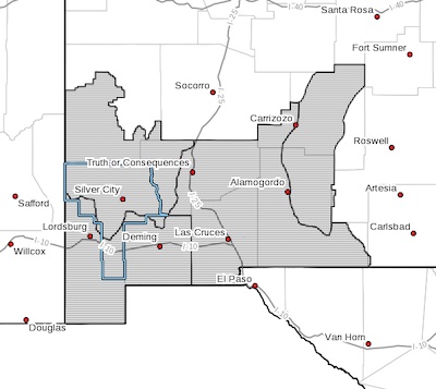
* AFFECTED AREA...Fire weather zone 110, 111, 112, and 113 in
Southwest and South Central New Mexico.
* WIND...Southwest winds 20 to 25 mph with gusts up to 35 mph.
* HUMIDITY...7 to 14 percent.
* HIGHEST THREAT...is located across fire weather zone 111 in
Southwest New Mexico.
* IMPACTS...any fires that develop will likely spread rapidly.
Outdoor burning is not recommended.
PRECAUTIONARY/PREPAREDNESS ACTIONS...
A Red Flag Warning means that critical fire weather conditions
are either occurring now, or will shortly. A combination of
strong winds, low relative humidity, and warm temperatures can
contribute to extreme fire behavior.