 BULLETIN - EAS ACTIVATION REQUESTED
Flash Flood Warning
National Weather Service El Paso Tx/Santa Teresa NM
220 PM MDT Thu Jun 9 2022
The National Weather Service in El Paso Tx/Santa Teresa has extended a
* Flash Flood Warning for...
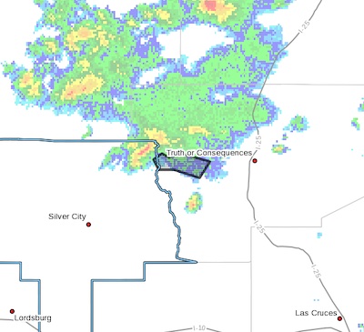
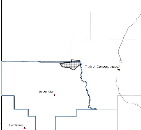
Western Sierra County in south central New Mexico...
North Central Grant County in southwestern New Mexico...
* Until 500 PM MDT.
* At 240 PM MDT, Doppler radar indicated thunderstorms producing
heavy rain across the warned area. Between 0.5 and 1.5 inches of
rain have fallen. Flash flooding is ongoing or expected to begin
shortly.
Excessive rainfall over the burn scar will result in debris flow
moving through Black Canyon Camp Ground. The debris flow can consist
of rock, mud, vegetation and other loose materials.
HAZARD...Flash flooding caused by thunderstorms.
SOURCE...Radar.
IMPACT...Flash flooding of small creeks and streams, urban
areas, highways, streets and underpasses as well as
other poor drainage and low-lying areas.
* Some locations that will experience flash flooding include...
mainly rural areas of Western Sierra and North Central Grant
Counties
PRECAUTIONARY/PREPAREDNESS ACTIONS...
This is a life threatening situation. Heavy rainfall will cause
extensive and severe flash flooding of creeks...streams...and
ditches in the Burn Scar. Severe debris flows can also be
anticipated across roads. Roads and driveways may be washed away in
places. If you encounter flood waters...climb to safety.
Turn around, don't drown when encountering flooded roads. Most flood
deaths occur in vehicles.
In hilly terrain there are numerous of low water crossings which are
potentially dangerous in heavy rain. Do not attempt to cross flooded
roads. Find an alternate route.
FLASH FLOOD...RADAR INDICATED