


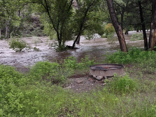
 During the August 2022 flooding at Grapevine Campground (Courtesy of Gila National Forest)By Mary Alice Murphy
On May 1, 2023, staff members from the Gila National Forest invited the public to interact at several tables set in the large meeting room at the Grant County Veterans Memorial Business and Conference Center. Forest Service personnel stood at each table to answer questions and explain, using Forest Service maps, the several options for camping they had developed for the public to comment on.
The purpose of the meeting was for members of the public to talk to GNF personnel to hear from them, as well as express opinions on options to deal with the closure of the Grapevine Campground on the Gila River near Gila Hot Springs.
[Background history: The Black Fire, the second largest in New Mexico history, burned a great deal of the upper watershed for the Mimbres and Gila rivers. The burn scar in the watershed that remained had little to no vegetation to slow down monsoonal flow from a robust monsoon season last year. As a result, not only extreme erosion occurred, but the high floods of water damaged, and in many cases destroyed, the irrigation infrastructure that farmers and ranchers rely on to water their crops and livestock. The major floods occurred primarily on Aug. 21 and 22, 2022. Because Grapevine Campground, managed by the Gila National Forest, also received damage, the gate was closed for camping.]
Now the Forest Service is resisting re-opening the campground.
Quite a few people attending opposed the total closure of the campground.
According to Maribeth Pecotte, GNF public affairs officer, among the reasons for the closure of the campground is that studies have shown that for two to five years after a catastrophic flood event as was experienced last August, similar flooding can occur and re-damage any repaired infrastructure.
Below are the options presented by the GNF (Gila National Forest) personnel.
Option 1: Remove campground designation.
This option would remove all existing infrastructure including bathrooms and campfire rings. The area would be open to public entry and camping with a 14-day stay limit. The area would be designated general forest, and motor vehicles may be parked one vehicle length, including any towed trailer, from the edge of Forest Service Road 528C.
Options 2 and 3 Redevelopment of the campground.
[This had seemed to be the preferred option by some of the attending public.] However, this was highlighted as: OPTIONS 2 AND 3 ARE NO LONGER OPTIONS. THE ENTIRE CAMPGROUND IS WITHIN THE 100-YEAR FLOODPALIN AND POLICY PREVENTS DEVELOPMENT WITHIN THE FLOODPLAIN.
The option HAD proposed building the campground above the flood plan, according to FS (Forest Service) standards and adding a seasonal area to Option 2.
A young man, whose name the Beat did not get, serves as the GNF hydrologist. He has recently mapped the area of the campground and declared that it is entirely within the 100-year flood plain.
Option 4 Day use only:
The official campground designation would be changed to day use area; the public could use the area during the day, but no overnight use would be allowed, and like option 1, motor vehicles may be parked one vehicle length, including any towed trailer, from the edge of Forest Service Road 528C.
Option 5 Remove campground designation, leave restrooms as part of the trailhead.
This option would also remove the campground designation, remove existing campfire rings, bathrooms would stay where they are and become part of the trailhead parking lot. Camping is discouraged at FS trailheads.
Option 6 Campground remains but is closed seasonally or as needed for public safety.
The campground would be managed for no more than 12 family units per Roaded Natural guidelines, and the area would be closed to overnight camping prior to the possibility of high-water events.
Common actions to all options include: acknowledging the unique recreational value placed on Grapevine Campground by agency personnel and the neighbors and visitors to the Gila National Forest; continuing foot and boat access to the Gila River; maintaining private property owners access to their property; constructing a vehicle barrier to protect riparian resources, allowing for foot traffic and private property access; the forest continuing to seek additional campground opportunities within the NM highway 15 corridor north of the NM highway 35 junction; continuing redesign by the Forest at Forks and Sapillo Campgrounds and maintaining dispersed camping opportunities at the Celebration/Skates area; as well as, "we will follow policy and law when making decisions."
Another potential campground could be developed at the XSX area, according to Pecotte.
Handouts to the participants included excerpts from the Forest Service Manual 2300—Recreation, Wilderness and Related Resource Management, 2330-2 addressing objectives, 2330-3 policy, 2330-6 safety, 2330-6a risk assessment and 2330-6b flash flood warning systems. The latter states: "Do not install, manage or operate a flash flood warning system.
Another handout had excerpts from Executive Order 11988—Floodplain Management and included Section 1; Sec. 2 as well as 2) and b), and Section 3 – c).
Excerpts from the Forest Service Handbook 2309.13 Recreation Site Handbook – Chapter 10 addressed 12.6 Resource Protection and Restoration; 12.10 Safety; 13.2 Camping units, as well as several excerpts from Chapter 50, addressing the site not adversely affecting natural amenities or cultural features; supporting natural setting, opportunities, access, scenic character and ecological functions; having the capacity to adapt to changing water conditions, energy needs, vegetation regimes, visitor demographics, economic outlook and climate. The handbook also stated where a practicable alternative exists outside the applicable floodplain, the proposed activity may not be located in the applicable floodplain. Where no practicable alternative exists, mitigation measures must be taken to reduce risk to an acceptable level. Where facilities are planned or exist in high-hazard areas, appropriate mitigation measures should be taken.
The latter mitigation measures are included in the options, and also may include signage and educational efforts, establishment of evacuation zones, and reducing the number of people, activities, structures and facilities in the applicable floodplain.
You can still offer comments to the Gila National Forest on the Grapevine Campground area by emailing them to comments-southwestern-gila@usda.gov.