


 [Editor's Note: Apologies for wrong date in headline. My brain thought yesterday was Saturday!]
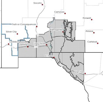
Southwest Desert/Mimbres Basin-Northern Dona Ana County-
Southern Dona Ana County/Mesilla Valley-Central Tularosa Basin-
Southern Tularosa Basin-
West Slopes Sacramento Mountains Below 7500 Feet-
Sacramento Mountains Above 7500 Feet-
East Slopes Sacramento Mountains Below 7500 Feet-Otero Mesa-
Western El Paso County-Eastern/Central El Paso County-
Northern Hudspeth Highlands/Hueco Mountains-Salt Basin-
Southern Hudspeth Highlands-
Rio Grande Valley of Eastern El Paso/Western Hudspeth Counties-
Rio Grande Valley of Eastern Hudspeth County-
Including the cities of Deming, Columbus, Garfield, Hatch,
Radium Springs, Las Cruces, Vado, Sunland Park, Alamogordo,
Tularosa, White Sands National Park, Chaparral, Orogrande,
White Sands Range Headquarters, Mescalero, Timberon,
Mountain Park, Cloudcroft, Sunspot, Apache Summit, Mayhill,
Pinon, Sacramento, Crow Flats, Downtown El Paso, West El Paso,
Upper Valley, East and Northeast El Paso, Socorro, Fort Bliss,
Hueco Tanks, Loma Linda, Cornudas, Dell City, Salt Flat,
Sierra Blanca, Fabens, Fort Hancock, Tornillo,
and Indian Hot Springs
144 AM MST Fri Feb 24 2023
...HIGH WIND WATCH IN EFFECT FROM SUNDAY MORNING THROUGH SUNDAY
EVENING...
* WHAT...West to southwest winds 30 to 45 mph with gusts up to 65
mph possible. Likely chances for stronger gusts in higher
terrain and on east slopes.
* WHERE...Portions of south central and southwest New Mexico and
southwest Texas.
* WHEN...From Sunday morning through Sunday evening.
* IMPACTS...Damaging winds could blow down trees and power
lines. Widespread power outages are possible. Travel could be
difficult, especially for high profile vehicles.
* ADDITIONAL DETAILS...A strong quick moving system will bring a
strong cold front across the region Sunday. Impactful west to
southwest winds will be strongest along the front for the desert
lowlands. Higher terrain and east slopes will see strong gusty
winds for most of the day Sunday. Precipitation chances will be
confined to the higher terrain, leaving soils dry. This leads
to high chances for widespread blowing dust in the lowlands
Sunday afternoon.
PRECAUTIONARY/PREPAREDNESS ACTIONS...
Monitor the latest forecasts and warnings for updates on this
situation. Fasten loose objects or shelter objects in a safe
location prior to the onset of winds.