


 FIRE WEATHER WATCH IN EFFECT FROM NOON THROUGH EARLY EVENING ON WEDNESDAY FOR PORTIONS OF THE SOUTH CENTRAL LOWLANDS OF NEW MEXICO AND FAR WEST TEXAS DUE TO VERY DRY AND WINDY CONDITIONS... .Strong southwest winds in the 20 to 30 mph range with higher gusts will combine with afternoon relative humidity dropping into the lower teens to single-digits to elevate fire danger and create critical fire weather conditions Wednesday afternoon.
NEW MEXICO FIRE WEATHER ZONE 112
SOUTH CENTRAL LOWLANDS AND SOUTHERN RIO GRANDE VALLEY/BLM/GLZ-
NEW MEXICO FIRE WEATHER ZONE 113
CAPITAN AND SACRAMENTO MOUNTAINS/LINCOLN NF/LNZ-
TEXAS FIRE WEATHER ZONE 055
EL PASO COUNTY-TEXAS FIRE WEATHER ZONE 056
HUDSPETH COUNTY-
337 AM MST Tue Feb 28 2023
...FIRE WEATHER WATCH IN EFFECT FROM WEDNESDAY AFTERNOON THROUGH
WEDNESDAY EVENING FOR STRONG WINDS AND VERY DRY CONDITIONS FOR
FIRE WEATHER ZONES 055, 056, 112, AND 113...
The National Weather Service in El Paso Tx/Santa Teresa has
issued a Fire Weather Watch, which is in effect from Wednesday
afternoon through early Wednesday evening.
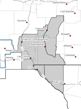
* AFFECTED AREA...This includes El Paso and Hudspeth counties in
Far West Texas and the New Mexico lowlands in Otero and southern
Dona Ana counties.
* 20 FOOT WIND...Southwest 20 to 30 mph with gust 40 to 50 mph.
* HUMIDITY...8 to 15 percent.
* IMPACTS...any fires that develop will likely spread rapidly.
Outdoor burning is not recommended.
PRECAUTIONARY/PREPAREDNESS ACTIONS...
A Fire Weather Watch means that critical fire weather conditions
are forecast to occur. Listen for later forecasts and possible
Red Flag Warnings.