


Weather
Winter Weather Advisory 0331-040124
 WINTER WEATHER ADVISORY IN EFFECT FROM MIDNIGHT TO NOONMDT MONDAY...
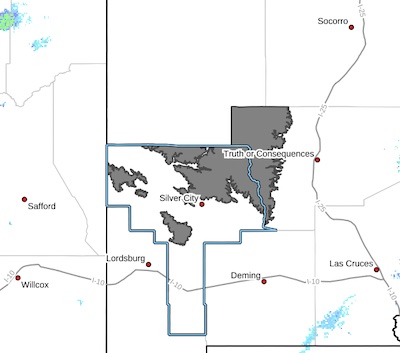
* WHAT...Snow expected. Total snow accumulations 2-5 inches above
7500 ft elevation. Winds gusting as high as 50 mph.
* WHERE...Southern Gila Region Highlands/Black Range.
* WHEN...From midnight this evening to noon MDT Monday.
Wind Advisory 033124
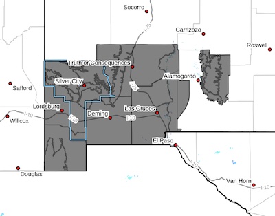 Upper Gila River Valley-Southern Gila Foothills/Mimbres Valley-
Southwest Desert/Lower Gila River Valley-Lowlands of the Bootheel-
Uplands of the Bootheel-Southwest Desert/Mimbres Basin-Eastern
Black Range Foothills-Sierra County Lakes-Northern Dona Ana County-Southern Dona Ana County/Mesilla Valley-West Slopes
Sacramento Mountains Below 7500 Feet-Sacramento Mountains Above
7500 Feet-East Slopes Sacramento Mountains Below 7500 Feet-
Extended time: Dense Fog Advisory 032824 AM
 Upper Gila River Valley-
Including the cities of Mule Creek, Buckhorn, Cliff, and Gila Hot
Springs
829 AM MDT Wed Mar 27 2024
...DENSE FOG ADVISORY IN EFFECT UNTIL 11 AM MDT THURSDAY...
* WHAT...Visibility below 1 mile in dense fog.
* WHERE...Upper Gila River Valley.
* WHEN...Until 10 AM MDT Thursday.
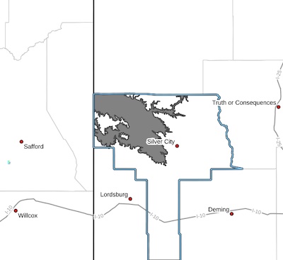
UPDATED: Difficult Driving Conditions Silver City Area 032624
Roadways around Silver City are reported as clear and drying, removed from NM Roads.
ROAD ADVISORY
Difficult Driving Conditions Silver City Area
The Silver City Patrol reported the roadways with heavy snowfall and could become icy. Please drive with caution, reduce speed, and obey all posted traffic signs. The NMDOT is out plowing and will continue to monitor roadways. This event will be updated as conditions change.
ROAD ADVISORY
Difficult Driving Conditions in Silver City/Black Range Area
NM 152 is reported at snow packed & icy from milepost 15 (San Lorenzo) to milepost 40(Kingston). Please be sure to drive with caution, reduce speed, and follow all posted traffic signs. The NMDOT is out plowing and will continue to monitor. This event will be updated as conditions change.
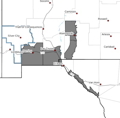
High Wind Warning- 2 for 032424
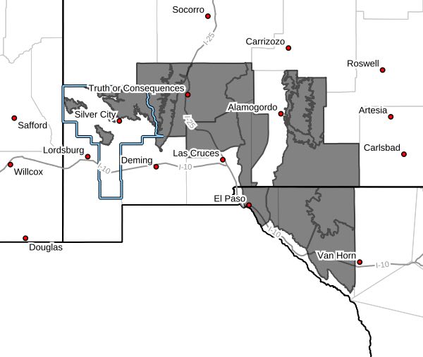 Eastern Black Range Foothills-Sierra County Lakes-Northern Dona
Ana County-West Slopes Sacramento Mountains Below 7500 Feet-
Sacramento Mountains Above 7500 Feet-East Slopes Sacramento
Mountains Below 7500 Feet-Otero Mesa-Southern Gila Region
Highlands/Black Range-West Central Tularosa Basin/White Sands-
Eastern/Central El Paso County-Northern Hudspeth Highlands/Hueco
Mountains-Salt Basin-Southern Hudspeth Highlands-
Including the cities of Mountain Park, Dell City, Sierra Blanca,
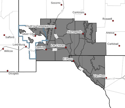
High Wind Warning 032424
 Southwest Desert/Mimbres Basin-Southern Dona Ana County/Mesilla
Valley-East Central Tularosa Basin/Alamogordo-Southeast Tularosa
Basin-Western El Paso County-Rio Grande Valley of Eastern El
Paso/Western Hudspeth Counties-Rio Grande Valley of Eastern
Hudspeth County-
Including the cities of Deming, Fabens, Las Cruces, Holloman AFB,
Sunland Park, Alamogordo, Vado, Downtown El Paso, Tornillo, West
El Paso, Indian Hot Springs, Fort Hancock, Tularosa, Columbus,
Orogrande, and Upper Valley
139 PM MDT Fri Mar 22 2024
High Wind Watch 032424
 Southwest Desert/Mimbres Basin-Eastern Black Range Foothills-
Sierra County Lakes-Northern Dona Ana County-Southern Dona Ana
County/Mesilla Valley-West Slopes Sacramento Mountains Below
7500 Feet-Sacramento Mountains Above 7500 Feet-East Slopes
Sacramento Mountains Below 7500 Feet-Otero Mesa-Southern Gila
Region Highlands/Black Range-West Central Tularosa Basin/White
Sands-East Central Tularosa Basin/Alamogordo-Southeast Tularosa
Basin-Western El Paso County-Eastern/Central El Paso County-
Removed: Large area of blowing dust 031524
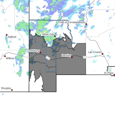 Southern Gila Foothills/Mimbres Valley-
Southwest Desert/Lower Gila River Valley-Lowlands of the Bootheel-
Southwest Desert/Mimbres Basin-
Including the cities of Hurley, Faywood, Grant County Airport,
Lordsburg, Red Rock, Virden, Antelope Wells, Animas, Hachita,
Deming, and Columbus
543 PM MDT Fri Mar 15 2024
...LARGE AREA OF BLOWING DUST OVER THE DESERT FROM ABOUT DEMING
WEST TO LORDSBURG...