


Weather
Strong thunderstorm 052023
 Southwest Desert/Lower Gila River Valley NM-
303 PM MDT Sat May 20 2023
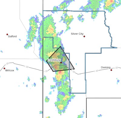
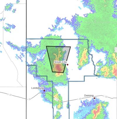
...A strong thunderstorm will impact portions of west central Grant
and northwestern Hidalgo Counties through 345 PM MDT...
At 301 PM MDT, Doppler radar was tracking a strong thunderstorm 7
miles west of Lordsburg, moving northeast at 25 mph.
HAZARD...Winds in excess of 30 mph.
SOURCE...Radar indicated.
IMPACT...Gusty winds could knock down tree limbs and blow around
unsecured objects. Heavy rain will continue to result in
reduced visibilities for motorists along I-10 near
Lordsburg.
Locations impacted include...
Lordsburg, Lordsburg Playa, Shakespeare and Pyramid Mountains.
This includes Interstate 10 in New Mexico between mile markers 11 and
35.
PRECAUTIONARY/PREPAREDNESS ACTIONS...
If outdoors, consider seeking shelter inside a building.
Torrential rainfall is also occurring with this storm and may lead to
localized flooding. Do not drive your vehicle through flooded
roadways.
Frequent cloud to ground lightning is occurring with this storm.
Lightning can strike 10 miles away from a thunderstorm. Seek a safe
shelter inside a building or vehicle.
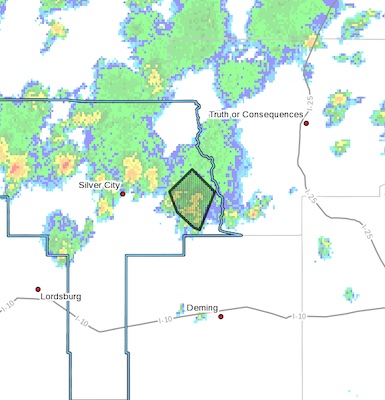
Flood Advisory- 2-)51623
 [Editor's Note: For your protection be aware when it is raining in areas above you into watersheds that may flood. Be aware. Note that not all advisories are posted here. It's up to you to remain safe!]
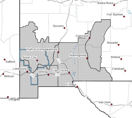
FLOOD ADVISORY IN EFFECT UNTIL 345 PM MDT THIS AFTERNOON...
* WHAT...Arroyo and small stream flooding caused by excessive
rainfall is expected.
* WHERE...A portion of southwest New Mexico, including the following
county, Grant.
* WHEN...Until 345 PM MDT.
* IMPACTS...Rises in small streams and normally dry arroyos. Some
low-water crossings may become impassable.
* ADDITIONAL DETAILS...
Flood Advisory in effect this afternoon 051623
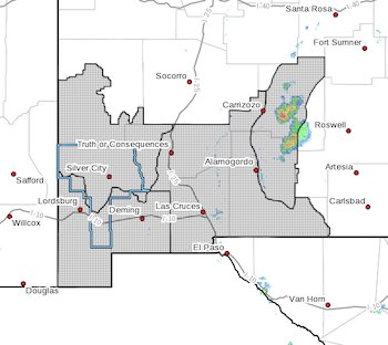
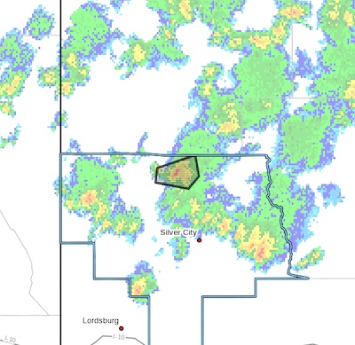 FLOOD ADVISORY IN EFFECT UNTIL 330 PM MDT THIS AFTERNOON...
* WHAT...Flooding caused by excessive rainfall is expected.
* WHERE...A portion of southwest New Mexico, including the following
county, Grant.
* WHEN...Until 330 PM MDT.
* IMPACTS...Rises in small streams and normally dry arroyos. River
or stream flows are elevated.
* ADDITIONAL DETAILS...
Flood Advisory this evening 051423
 FLOOD ADVISORY IN EFFECT UNTIL 10 PM MDT THIS EVENING...
* WHAT...Flooding caused by excessive rainfall is expected.
* WHERE...A portion of southwest New Mexico, including the following
county, Grant.
* WHEN...Until 1000 PM MDT.
* IMPACTS...Minor flooding in low-lying and poor drainage areas.
Dangerous flows over low-water crossings.
* ADDITIONAL DETAILS...
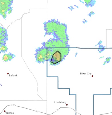
Strong thunderstorm warning north central Grant County 051323
 Southern Gila Highlands/Black Range NM-Upper Gila River Valley NM-
753 PM MDT Sat May 13 2023
...A strong thunderstorm will impact portions of north central Grant
County through 830 PM MDT...
At 753 PM MDT, Doppler radar was tracking a strong thunderstorm 4
miles southeast of Mangas Springs, moving north at 25 mph.
HAZARD...Winds in excess of 30 mph and penny size hail.
SOURCE...Radar indicated.
IMPACT...Gusty winds could knock down tree limbs and blow around
unsecured objects. Minor damage to outdoor objects is
possible.
Locations impacted include...
Cliff, Silver City, Mangas Springs, Oak Grove, Riverside, Gila,
Mangas Valley, Bill Evans Lake, Sapillo Creek Valley, Tyrone Mine,
Mogollon Box Campground, Little Walnut Village and Portions of the
Gila Wilderness.
PRECAUTIONARY/PREPAREDNESS ACTIONS...
Wind Advisory 051023
 [Editor's Note: Other than a slight difference in the map, I don't know what the difference is with the Red Flag Warning that was updated this morning earlier.]
Upper Gila River Valley-Southern Gila Highlands/Black Range-
Southern Gila Foothills/Mimbres Valley-
Southwest Desert/Lower Gila River Valley-Lowlands of the Bootheel-
Uplands of the Bootheel-Southwest Desert/Mimbres Basin-
Eastern Black Range Foothills-Sierra County Lakes-
Northern Dona Ana County-Southern Dona Ana County/Mesilla Valley-
Central Tularosa Basin-Southern Tularosa Basin-
Including the cities of Cliff, Buckhorn, Gila Hot Springs,
Mule Creek, Silver City, Lake Roberts, Kingston, Fort Bayard,
Mimbres, Hurley, Faywood, Grant County Airport, Lordsburg,
Red Rock, Virden, Antelope Wells, Animas, Hachita, Cloverdale,
Deming, Columbus, Hillsboro, Winston, Truth Or Consequences,
UPDATED: Red Flag Warning 051023
RED FLAG WARNING IN EFFECT FOR WEDNESDAY AFTERNOON AND EVENING FOR SOUTHWEST AND SOUTH CENTRAL NEW MEXICO... .The region continues in an extended period of warm and dry conditions, as deep southwest flow delivers breezy afternoons. As such, fuels are continuing to dry. On Wednesday a Pacific low will eject across the Four Corners Region, tightening pressure gradients and inducing surface troughing. This will increase wind speeds across the area on Wednesday. A windy afternoon and evening will elevate fire weather conditions to critical. The probability for new wildfire starts and large growth of any existing fires will be increased. Winds will decrease for the end of the week, but RH's will remain low. Relief is possible by Saturday as moisture looks to move in from the east to raise relative humditiy, and bring scattered rain showers.
Fire Weather Watch for Friday 050523
 FIRE WEATHER WATCH IN EFFECT FRIDAY AFTERNOON AND EVENING FOR THE LOWLANDS AND MOUNTAINS OF SOUTHWEST AND SOUTH CENTRAL NEW MEXICO... .Conditions dry out on Thursday as the plume of moisture departs to the east. A deep upper trough over the Great Basin will induce a moderately strong surface low in southeast Colorado and result in breezy conditions for Friday. Temperatures remain near average for early May with deep thermal mixing during the afternoon and even drier air than Thursday. Southwest winds of 20 to 25 mph with gusts up to 35 mph are expected on Friday. Minimum RHs will be 7 to 10 percent in the lowlands and 10 to 15 percent in the mountains. Fire weather conditions will improve Friday night as winds subside and relative humidity recovers above critical levels.
...FIRE WEATHER WATCH IN EFFECT FROM FRIDAY AFTERNOON THROUGH
FRIDAY EVENING FOR BREEZY WINDS AND DRY CONDITIONS FOR FIRE
WEATHER ZONES 110, 111, 112, AND 113...