 CRITICAL FIRE WEATHER CONDITIONS LIKELY THURSDAY SOUTHWEST NEW MEXICO AND SOUTH CENTRAL MOUNTAINS OF NEW MEXICO... Dry and breezy weather pattern Wednesday and Thursday will set the stage for critical fire weather conditions across the New Mexico fire zones for Thursday. A shortwave trough coming across the Southern Rockies will induce surface low pressure in the Southern Plains on Thursday. West winds of 20 to 25 mph are forecast with gusts to 35 mph during the afternoon. Minimum relative humidity values of 7 to 15 percent are forecast. Widespread tree mortality and die back fuels will increase the wildfire risk as ERCs climb towards the 90th percentile.
Southwest Mountains/Gila NF/Apache NF/GLZ-
Southwest Deserts and Lowlands/Las Cruces BLM/GLZ-
South Central Lowlands and Southern Rio Grande Valley/BLM/GLZ-
Capitan and Sacramento Mountains/Lincoln NF/LNZ-
551 AM MDT Wed Apr 22 2026
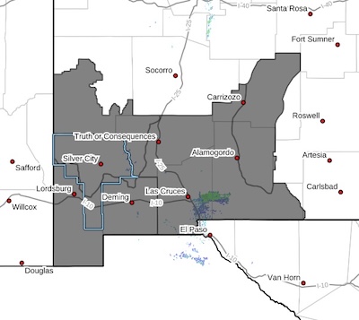
...RED FLAG WARNING IN EFFECT FROM 10 AM TO 8 PM MDT THURSDAY FOR
LOW HUMIDITY, STRONG WINDS, AND DRY FUELS...
The National Weather Service in El Paso Tx/Santa Teresa has
issued a Red Flag Warning, which is in effect from 10 AM to 8 PM
MDT Thursday. The Fire Weather Watch is no longer in effect.
* AFFECTED AREA...New Mexico Fire Weather Zones 110, 111, 112, and
113, including the Southwest Mountains and Gila NF, the
Southwest Deserts and Lowlands, the South Central Lowlands and
Southern Rio Grande Valley, and the Capitan and Sacramento
Mountains.
* TIMING...winds increasing after 10 am, and peaking in the
late afternoon hours.
* WINDS...West 15 to 25 mph with gusts up to 35 mph.
* RELATIVE HUMIDITY...7-10 percent.
* EXPERIMENTAL RFTI...3 to 5, Near Critical to Critical.
* IMPACTS...any fires that develop will likely spread rapidly.
Outdoor burning is not recommended.
PRECAUTIONARY/PREPAREDNESS ACTIONS...
A Red Flag Warning means that critical fire weather conditions
are either occurring now, or will shortly. A combination of
strong winds, low relative humidity, and warm temperatures can
contribute to extreme fire behavior.