 MARGINALLY CRITICAL FIRE WEATHER CONDITIONS FOR MUCH OF SOUTHWEST AND SOUTH-CENTRAL NEW MEXICO THIS AFTERNOON... .Very warm and dry conditions will continue today, with afternoon winds increasing to around 18 to 25 mph with gusts 30 to 35 mph. Meanwhile, minimum RH values will dip to around 10 percent in the lowlands, and the lower teens below about 7500 feet. ERC values are around the 85th percentile, and forecast to reach 90th percentile this weekend.
NMZ110-141730-
/O.NEW.KEPZ.FW.W.0012.260514T1800Z-260515T0200Z/
Southwest Mountains/Gila NF/Apache NF/GLZ-
321 AM MDT Thu May 14 2026
...RED FLAG WARNING IN EFFECT FROM NOON TODAY TO 8 PM MDT THIS
EVENING FOR BREEZY WINDS AND LOW RELATIVE HUMIDITY...
The National Weather Service in El Paso Tx/Santa Teresa has
issued a Red Flag Warning, which is in effect from noon today to
8 PM MDT this evening.
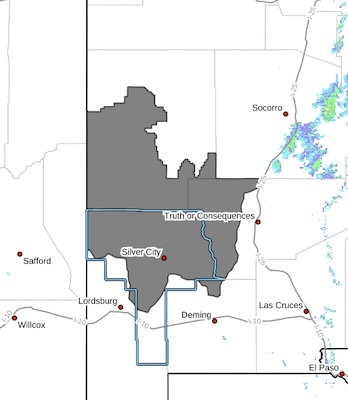
* AFFECTED AREA...Fire weather zone 110, encompassing the
Southwest Mountains/Gila NF
* TIMING...Winds will increase after 11 AM, peaking the
afternoon and early evening.
* WINDS...Southwest 18 to 25 mph with gusts up to 35 mph.
* RELATIVE HUMIDITY...Minimum RH 10 to 15 percent below 7500
feet. Minimum RH values will be closer to 20 percent at the
highest elevations.
* LIGHTNING...None expected.
* IMPACTS...any fires that develop will likely spread rapidly.
Outdoor burning is not recommended.
PRECAUTIONARY/PREPAREDNESS ACTIONS...
A Red Flag Warning means that critical fire weather conditions
are either occurring now, or will shortly. A combination of
strong winds, low relative humidity, and warm temperatures can
contribute to extreme fire behavior.