 CRITICAL FIRE WEATHER CONDITIONS POSSIBLE SUNDAY... .An upper level trough carving out over the Central Rockies will bring increasing southwest winds to the region over the next couple of days, while Relative Humidity values remain very low, and fuels remain critically dry. Winds aloft will begin to increase late tonight, with favored downslope areas seeing near- Red Flag conditions during the overnight and pre-dawn hours, as gusty winds help to create very poor RH recovery. Winds will stay strong along north and east-facing slopes Sunday night, and Red Flag conditions may persist through Sunday Night into Monday in those favored areas.
Southwest Mountains/Gila NF/Apache NF/GLZ-
Southwest Deserts and Lowlands/Las Cruces BLM/GLZ-
South Central Lowlands and Southern Rio Grande Valley/BLM/GLZ-Texas Fire Weather Zone 055 El Paso County-
1114 AM MDT Sat May 16 2026
...RED FLAG WARNING IN EFFECT FROM NOON SUNDAY TO MIDNIGHT MDT
SUNDAY NIGHT FOR STRONG WINDS AND LOW HUMIDITY FOR SOUTHWEST AND
SOUTH-CENTRAL NEW MEXICO AND PARTS OF FAR WEST TEXAS...
...FIRE WEATHER WATCH IN EFFECT FROM MONDAY AFTERNOON THROUGH
MONDAY EVENING FOR THE SAME AREA...
The National Weather Service in El Paso has issued a Red Flag
Warning for strong winds and low humidity, which is in effect
from noon Sunday to midnight MDT Sunday night. A Fire Weather
Watch has also been issued from Monday afternoon through Monday
evening.
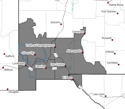
* AFFECTED AREA...All of southwest and south-central New Mexico,
including the Gila Region and the lowland deserts. Also, El Paso
County in Texas. This area includes New Mexico Fire Weather
Zones 110, 111, and 112, and Texas Fire Weather Zone 055.
* TIMING...Red Flag Warning on Sunday from Noon through Midnight.
Fire Weather Watch for Monday afternoon and evening.
* WINDS...Southwest 20 to 30 mph with gusts up to 50 mph on
Sunday, and slightly lower on Monday.
* RELATIVE HUMIDITY...As low as 5 percent.
* TEMPERATURES...Up to 90.
* LIGHTNING...None expected.
* EXPERIMENTAL RFTI...4 to 5.
* IMPACTS...any fires that develop will likely spread rapidly.
Outdoor burning is not recommended.
PRECAUTIONARY/PREPAREDNESS ACTIONS...
A Red Flag Warning means that critical fire weather conditions
are either occurring now, or will shortly. A combination of
strong winds, low relative humidity, and warm temperatures can
contribute to extreme fire behavior.
A Fire Weather Watch means that critical fire weather conditions
are forecast to occur. Listen for later forecasts and possible
Red Flag Warnings.