








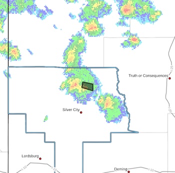
 Flash Flood Warning
National Weather Service El Paso Tx/Santa Teresa NM
242 PM MDT Fri Aug 28 2026
The National Weather Service in El Paso Tx/Santa Teresa has issued a
* Flash Flood Warning for...
Northeastern Grant County in southwestern New Mexico...
* Until 445 PM MDT.
* At 242 PM MDT, Doppler radar indicated thunderstorms producing heavy rain across the warned area. Between 1 and 1.5 inches of rain
have fallen. Additional rainfall amounts up to 0.5 inches are possible in the warned area. Flash flooding is ongoing or expected to begin shortly.
HAZARD...Flash flooding caused by thunderstorms.
SOURCE...Radar indicated.
IMPACT...Flash flooding of small creeks and streams, urban areas,
highways, streets and underpasses as well as other poor
drainage and low-lying areas.
* Some locations that will experience flash flooding include...
Lake Roberts, Sapillo Creek Valley, Trout Valley and Lake Roberts
Heights.
PRECAUTIONARY/PREPAREDNESS ACTIONS...
In hilly terrain there are hundreds of low water crossings which are
potentially dangerous in heavy rain. Do not attempt to cross flooded
roads. Find an alternate route.
Remain alert for flooding even in locations not receiving rain.
Arroyos, streams, and rivers can become raging killer currents in a
matter of minutes, even from distant rainfall.
Move away from recently burned areas. Life-threatening flooding of
creeks, roads and normally dry arroyos is likely. The heavy rains
will likely trigger rockslides, mudslides and debris flows in steep
terrain, especially in and around these areas.
[Editor's Note: It's still monsoon season, so please be prepared for flooding if you live in a flood prove area.]