








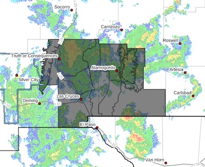
 Eastern Black Range Foothills-Sierra County Lakes-Northern Dona Ana County-Southern Dona Ana County/Mesilla Valley-West Slopes Sacramento Mountains Below 7500 Feet-Sacramento Mountains Above 7500 Feet-East Slopes Sacramento Mountains Below 7500 Feet-Otero Mesa-West Central Tularosa Basin/White Sands-East Central Tularosa Basin/Alamogordo-Southeast Tularosa Basin-
Including the cities of Mescalero, Truth Or Consequences, Las Cruces, White Sands National Park, Radium Springs, Tularosa, Sunspot, Orogrande, Mayhill, Garfield, Alamogordo, Timberon, Cloudcroft, Pinon, Chaparral, Hillsboro, White Sands Range Headquarters, Apache Summit, Sacramento, Spaceport, Hatch, Vado, Holloman AFB, Sunland Park, Mountain Park, Winston, Crow Flats, and Derry 909 PM MDT Tue Sep 22 2026
...FLOOD WATCH REMAINS IN EFFECT...
The Flood Watch remains in effect through Wednesday evening for
south-central New Mexico, including Dona Ana and Otero Counties, and
a portion of Sierra County.
* WHAT...Flooding caused by excessive rainfall is likely.
* WHERE...South-central New Mexico.
* WHEN...Through midnight Wednesday night.
* IMPACTS...Excessive runoff may result in flooding of rivers,
creeks, streams, and other low-lying and flood-prone locations.
Creeks and streams may rise out of their banks. Low-water crossings
may be flooded. Flood structures, like levees and dams, may be
tested.
* ADDITIONAL DETAILS...
- A late season plume of deep tropical moisture is transported
northward ahead of an upper-level disturbance, bringing several
rounds of thunderstorms with high rainfall rates to the region
through Wednesday evening. Repeated thunderstorms will result in
scattered to numerous instances of flash flooding with some
considerable cases. Wednesday morning is the most likely time to
see excessive rainfall. Rainfall amounts around 2 inches are
likely with isolated amounts of 4 inches or more.
- Central Dona Ana County through southeastern Sierra County are
most likely to see the heaviest rainfall through Wednesday
morning.
- http://www.weather.gov/safety/flood
PRECAUTIONARY/PREPAREDNESS ACTIONS...
You should monitor later forecasts and be alert for possible Flood
Warnings. Those living in areas prone to flooding should be prepared
to take action should flooding develop.