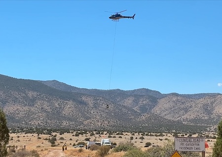
 Forest Service Photo: Aviation support on Six Mile Fire on the Magdalena Ranger District of the Cibola National Forest & National Grasslands. May 11, 2026Suppression efforts lead to 24% containment
MAP Below article
Acres: 341
Start Date: May 8, 2026
Cause: Undetermined
Containment: 24%
Personnel: 296
Fuels: Short Grass, brush, oak and pinyon/juniper
Location: 12 miles SE of Magdalena, NM. See map attached.
Operations: Crews continued structure assessment and preparation work around the Langmuir Observatory yesterday and will remain engaged in those efforts today. Firefighters are also preparing the 370 Trail corridor off Forest Service Road 325, working south toward the Sawmill Fire scar to strengthen contingency options and improve potential containment features.
Crews assigned to the fire continued securing portions of the fire perimeter using direct suppression tactics in steep, remote terrain. With elevated fire weather conditions forecasted across the region, fire managers are evaluating resource needs and identifying personnel and equipment that may be reassigned from remote sections of the fireline to support response capability for any potential new fire starts.
Weather: A deep and dry westerly flow pattern returns Thursday and Friday, with seasonably warm and dry conditions, with moderately breezy afternoons. Due to the season, the drought and fuel conditions, these warm, dry, and breezy conditions will mean elevated fire weather.
Closures: A closure order remains in effect for multiple roads and trails within the fire area. Refer to Cibola National Forest website for further details. https://www.fs.usda.gov/r03/cibola/alerts.
Safety: The health and safety of firefighters and the public are always the top priority. Fire equipment and personnel will be operating on area road systems, and the public should remain aware of current and any upcoming area closures associated with suppression activities. Drones pose a serious risk to firefighting. The public is reminded that "If you fly, we can't!"
Smoke is minimal within the fire area but may be visible from Highway 60. An interactive smoke map at https://fire.airnow.gov/ allows you to zoom into your area to see live smoke conditions.
Additional Information:
Inciweb: https://inciweb.wildfire.gov/incident-information/nmcif-six-mile-fire
Facebook: https://www.facebook.com/cibolanf
New Mexico Fire Info: https://nmfireinfo.com/
Email: