


 Flash Flood Warning
National Weather Service El Paso Tx/Santa Teresa NM
1201 PM MDT Thu Jun 26 2025
The National Weather Service in El Paso Tx/Santa Teresa has issued a
* Flash Flood Warning for...
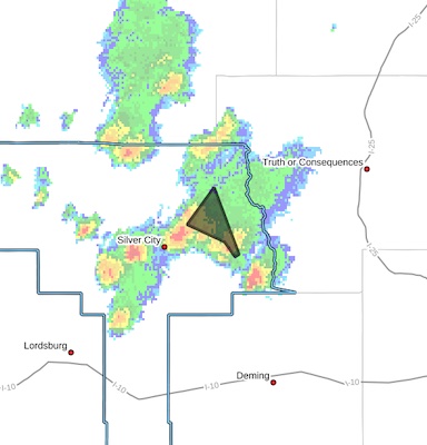
Northeastern Grant County in southwestern New Mexico...
* Until 300 PM MDT.
* At 1201 PM MDT, Emergency management reported thunderstorms
producing heavy rain across the warned area. Between 1 and 1.5
inches of rain have fallen. Flash flooding is ongoing or expected
to begin shortly.
HAZARD...Life threatening flash flooding. Thunderstorms
producing flash flooding.
SOURCE...Emergency management reported.
IMPACT...Life threatening flash flooding of creeks and streams,
urban areas, highways, streets and underpasses.
* Some locations that will experience flash flooding include...
San Lorenzo, Mimbres, San Juan, Georgetown, Camp Thunderbird and
Upper Mimbres Valley.
This includes the following streams and drainages...
Lampbright Draw, Stephens Creek, Sapillo Creek, West Fork Mimbres
River, Mimbres River, East Fork Mimbres River and Hanover Creek.
PRECAUTIONARY/PREPAREDNESS ACTIONS...
Turn around, don't drown when encountering flooded roads. Most flood
deaths occur in vehicles.
Be aware of your surroundings and do not drive on flooded roads.


