



 Click to Search
Search
[{{{type}}}] {{{reason}}}
{{/data.error.root_cause}}
{{{_source.title}}} {{#_source.showPrice}} {{{_source.displayPrice}}} {{/_source.showPrice}}
{{#_source.showLink}} {{/_source.showLink}} {{#_source.showDate}}{{{_source.displayDate}}}
{{/_source.showDate}}{{{_source.description}}}
{{#_source.additionalInfo}}{{#_source.additionalFields}} {{#title}} {{{label}}}: {{{title}}} {{/title}} {{/_source.additionalFields}}
{{/_source.additionalInfo}}


Weather
- Category: Weather
ROAD ADVISORY
FLOODING – Mimbres/Lake Roberts Area
NM 35 from milepost 27 to 5, Mimbres, has water running over the roadway at low water crossings, roadway is still passable. NMDOT is currently monitoring and will notify as conditions change.
When the roadway is flooded do not cross and seek an alternate route. Turn around, don't drown.
DEMING/COLUMBUS - DIFFICULT DRIVING CONDITIONS
- Category: Weather
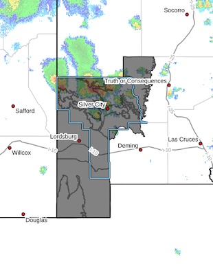 [Editor's Note: Sorry this is so late, but tech glitches have slowed us down today. and other flood watches have come in, so please be prepared!!]
Upper Gila River Valley-Southern Gila Foothills/Mimbres Valley-
Southwest Desert/Lower Gila River Valley-Lowlands of the Bootheel-
Uplands of the Bootheel-Central Grant County/Silver City Area-
Southern Gila Region Highlands/Black Range-
Including the cities of Mimbres, Cloverdale, Fort Bayard,
Lordsburg, Grant County Airport, Gila Hot Springs, Hachita,
Silver City, Animas, Red Rock, Faywood, Virden, Lake Roberts,
Mule Creek, Cliff, Buckhorn, Antelope Wells, Hurley, and Kingston
950 AM MDT Tue Jul 28 2026
...FLOOD WATCH IN EFFECT THROUGH THIS EVENING...
* WHAT...Flooding caused by excessive rainfall is possible.
* WHERE...Portions of Southwest New Mexico, including Silver City
and Lordsburg.
- Category: Weather
High wind warning in Luna County. High profile vehicles please use caution. The NMDOT will continue monitoring the roadway. This event will be updated as conditions change.
- Category: Weather
ROAD ADVISORY
FLOODING – Mimbres/Lake Roberts Area
NM 35 from milepost 27 to 5, Mimbres, has water running over the roadway at low water crossings, roadway is still passable. NMDOT is currently monitoring and will notify as conditions change.
When the roadway is flooded do not cross and seek an alternate route. Turn around, don’t drown.
- Category: Weather
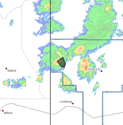 FLOOD ADVISORY IN EFFECT UNTIL 645 PM MDT THIS EVENING...
* WHAT...Arroyo and small stream flooding caused by excessive
rainfall is expected.
* WHERE...A portion of southwest New Mexico, including the following county, Grant.
* WHEN...Until 645 PM MDT.
* IMPACTS...Minor flooding in low-lying and poor drainage areas.
Rises in small streams and normally dry arroyos.
* ADDITIONAL DETAILS...
- At 443 PM MDT, Doppler radar indicated heavy rain due to
thunderstorms. This will cause arroyo and small stream
flooding. Between 1 and 1.5 inches of rain have fallen.
- Some locations that may experience flooding include...
mainly rural areas of Northwestern Grant County
- http://www.weather.gov/safety/flood
- Category: Weather
ROAD ADVISORY
DIFFICULT DRIVING – ANIMAS
NM 9 east and westbound from milepost 56 to 60 will be rough driving. Roadway is open for travel, but travelers should expect uneven pavement. Motorists are asked to reduce speed, obey posted signs, and watch for construction personnel and equipment. Please use caution and expect delays.
FLOODING – Animas Area
Closure, NM 145 eastbound and westbound from mile marker 0, at NM 80 to mile marker 3, 3 miles east of NM 80, is closed due to flooding. Use extreme caution.
When the roadway is flooded do not cross and seek an alternate route. Turn around, don’t drown.
- Category: Weather
ROAD ADVISORY
FLOODING – Mimbres Area
Difficult Driving Conditions, NM 35 northbound and southbound at mile marker 9 (Allie Canyon), 9 miles north of NM 152, has running water over the roadway at low water crossings, roadway is not passable. NMDOT is currently monitoring and will notify as conditions change.
When the roadway is flooded do not cross and seek an alternate route. Turn around, don’t drown.
- Category: Weather
NM 11 northbound at mile marker 4 (Columbus) to mile marker 17 is now open. Removed from NM Roads.
Road Closure, NM 11 northbound at mile marker 4 (Columbus) to mile marker 17, 9 miles south of Sunshine. Roadway is closed due to flooding. Use extreme caution.
FLOODING – Deming/Columbus Area, as well as Cotton City
Difficult Driving Conditions, NM 11 northbound and southbound at mile marker 17, 9 miles south of Sunshine, .there is running water on roadway. Use extreme caution.
When the roadway is flooded do not cross and seek an alternate route. Turn around, don’t drown.





Content on the Beat
WARNING: All articles and photos with a byline or photo credit are copyrighted to the author or photographer. You may not use any information found within the articles without asking permission AND giving attribution to the source. Photos can be requested and may incur a nominal fee for use personally or commercially.
Disclaimer: If you find errors in articles not written by the Beat team but sent to us from other content providers, please contact the writer, not the Beat. For example, obituaries are always provided by the funeral home or a family member. We can fix errors, but please give details on where the error is so we can find it. News releases from government and non-profit entities are posted generally without change, except for legal notices, which incur a small charge.
NOTE: If an article does not have a byline, it was written by someone not affiliated with the Beat and then sent to the Beat for posting.
Images: We have received complaints about large images blocking parts of other articles. If you encounter this problem, click on the title of the article you want to read and it will take you to that article's page, which shows only that article without any intruders.
New Columnists: The Beat continues to bring you new columnists. And check out the old faithfuls who continue to provide content.
Newsletter: If you opt in to the Join GCB Three Times Weekly Updates option above this to the right, you will be subscribed to email notifications with links to recently posted articles.
Editor's Notes
It has come to this editor's attention that people are sending information to the Grant County Beat Facebook page. Please be aware that the editor does not regularly monitor the page. If you have items you want to send to the editor, please send them to editor@grantcountybeat.com. Thanks!
Here for YOU: Consider the Beat your DAILY newspaper for up-to-date information about Grant County. It's at your fingertips! One Click to Local News. Thanks for your support for and your readership of Grant County's online news source—www.grantcountybeat.com
Feel free to notify editor@grantcountybeat.com if you notice any technical problems on the site. Your convenience is my desire for the Beat. The Beat totally appreciates its readers and subscribers!
Compliance: Because you are an esteemed member of The Grant County Beat readership, be assured that we at the Beat continue to do everything we can to be in full compliance with GDPR and pertinent US law, so that the information you have chosen to give to us cannot be compromised.
Submitting to the Beat
Those new to providing news releases to the Beat are asked to please check out submission guidelines at https://www.grantcountybeat.com/about/submissions. They are for your information to make life easier on the readers, as well as for the editor.
Advertising: Don't forget to tell advertisers that you saw their ads on the Beat.
Classifieds: We have changed Classifieds to a simpler option. Check periodically to see if any new ones have popped up. Send your information to editor@grantcountybeat.com and we will post it as soon as we can. Instructions and prices are on the page.