


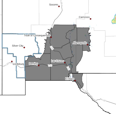
 Southwest Desert/Mimbres Basin-Sierra County Lakes-Northern Dona
Ana County-Southern Dona Ana County/Mesilla Valley-West Central
Tularosa Basin/White Sands-East Central Tularosa Basin/Alamogordo-
Eastern/Central El Paso County-
Including the cities of Vado, East and Northeast El Paso,
Alamogordo, Hatch, Sunland Park, Spaceport, Fort Bliss, Garfield,
Las Cruces, Chaparral, Holloman AFB, Tularosa, White Sands
National Park, Deming, Socorro, Columbus, White Sands Range
Headquarters, Radium Springs, Derry, and Truth Or Consequences
259 PM MDT Sat Apr 26 2025
...BLOWING DUST ADVISORY IN EFFECT FROM 11 AM TO 8 PM MDT SUNDAY...
...HIGH WIND WARNING REMAINS IN EFFECT FROM 11 AM TO 8 PM MDT
SUNDAY...
* WHAT...For the Blowing Dust Advisory, visibility between
one-quarter and one mile in blowing dust expected. For the High
Wind Warning, southwest winds 30 to 40 mph with gusts up to 60 mph
expected.
* WHERE...Rio Grande Valley of New Mexico, Southwest Desert/Mimbres
Basin, West Central Tularosa Basin/White Sands, East Central
Tularosa Basin/Alamogordo, and Eastern/Central El Paso County.
* WHEN...From 11 AM to 8 PM MDT Sunday.
* IMPACTS...Hazardous driving conditions due to reduced visibility.
Damaging winds will blow down trees and power lines. Widespread
power outages are expected. Travel will be difficult, especially
for high profile vehicles.
PRECAUTIONARY/PREPAREDNESS ACTIONS...
Persons with respiratory problems should make preparations to stay
indoors until the storm passes. Be ready for a sudden drop in
visibility to near zero. If you encounter blowing dust or blowing
sand on the roadway or see it approaching, pull off the road as far
as possible and put your vehicle in park. Turn the lights all the
way off and keep foot off the brake pedal. Remember, 'Pull Aside,
Stay Alive'.
Remain in the lower levels of your home during the windstorm, and
avoid windows. Watch for falling debris and tree limbs. Use caution
if you must drive.


