


 Flash Flood Warning
National Weather Service El Paso Tx/Santa Teresa NM 203 PM MDT Mon Jul 7 2025
The National Weather Service in El Paso Tx/Santa Teresa has issued a
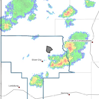
* Flash Flood Warning for...The Trout Fire burn scar in...North Central Grant County in southwestern New Mexico...
* Until 430 PM MDT.
* At 203 PM MDT, Doppler radar indicated thunderstorms producing heavy rain over the Trout Fire burn scar. Between 0.3 and 0.5
inches of rain have fallen. Flash flooding is ongoing or expected to begin shortly.
Excessive rainfall over the burn scar will result in debris flow moving through the Trout Fire Burn Scar, into canyons flowing north towards Sapillo Creek ABOVE Lake Roberts Dam, including Hill Canyon and Skates Canyon. Sapillo Creek UPSTREAM...or EAST of Lake Roberts Dam will also be impacted. The debris flow can consist of rock, mud, vegetation and other loose materials.
HAZARD...Life threatening flash flooding. Thunderstorms
producing flash flooding in and around the Trout Fire
burn scar.
SOURCE...Radar.
IMPACT...Life threatening flash flooding of areas in and around
the Trout Fire burn scar.
* Some locations that will experience flash flooding include...
Lake Roberts, Hill Canyon, Gattons Park, Three Circle Canyon and
Lake Roberts Heights.
PRECAUTIONARY/PREPAREDNESS ACTIONS...
This is a life threatening situation. Heavy rainfall will cause
extensive and severe flash flooding of creeks...streams...and
ditches in the Trout Fire burn scar. Severe debris flows can also be
anticipated across roads. Roads and driveways may be washed away in
places. If you encounter flood waters...climb to safety.
In hilly terrain there are numerous low water crossings which are
potentially dangerous in heavy rain. Do not attempt to cross flooded
roads. Find an alternate route.
Flooding is occurring or is imminent. It is important to know where
you are relative to streams, rivers, or creeks which can become
killers in heavy rains. Campers and hikers should avoid streams or
creeks.


