


 .
.
.CRITICAL FIRE DANGER THROUGH THIS AFTERNOON WEST OF THE DIVIDE... ...EXTREMELY CRITICAL FIRE DANGER ON MONDAY ACROSS THE REGION... A cut off low will bringing windy south to southwest winds of 15 to 25 mph with gusts of 35 to 40 mph to the area this morning through this afternoon. Min RH values in the single digits are in the forecast coupled with gusty winds and very dry fuels which will lead to dangerous fire weather conditions across southwest New Mexico. Another, stronger storm system will cross the area on Monday and bring west to southwest winds of 25 to 40 mph with gusts of 50 to 60 mph possible. These winds will combine with RH's in the 5 to 15 percent range and very dry conditions to create very critical fire conditions.
...RED FLAG WARNING IN EFFECT FROM 11 AM TO 8 PM MST MONDAY FOR
STRONG WINDS AND LOW RH VALUES FOR FIRE WEATHER ZONE 111...
The National Weather Service in El Paso Tx/Santa Teresa has
issued a Red Flag Warning for strong winds and low relative
humidities, which is in effect from 11 AM to 8 PM MST Monday. The
Fire Weather Watch is no longer in effect.
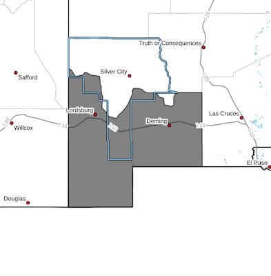
* AFFECTED AREA...Fire Weather Zone 111 Southwest Deserts and
Lowlands/Las Cruces BLM/GLZ.
* TIMING...Through 6 PM Today and
11 AM to 8 PM Monday
* WINDS...Today...West 25 to 35 mph with gusts up to 55 mph.
Monday...West to southwest 25 to 35 mph with gusts over 50 mph.
* RELATIVE HUMIDITY...As low as 7 percent today and Monday.
* TEMPERATURES...Up to 79 today and 60s on Monday.
* EXPERIMENTAL RFTI...5 to 7 today and 6 to 7 on Monday on the
scale of 0 to 10.
* IMPACTS...any fires that develop will likely spread rapidly.
Outdoor burning is not recommended.
PRECAUTIONARY/PREPAREDNESS ACTIONS...
A Red Flag Warning means that critical fire weather conditions
are either occurring now, or will shortly. A combination of
strong winds, low relative humidity, and warm temperatures can
contribute to extreme fire behavior.


