


Just in case, you can't hear the thunder and wind or aren't looking out a window, there's a strong thunderstorm in NE Grant County
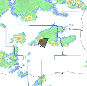 A STRONG THUNDERSTORM WILL IMPACT NORTHEASTERN GRANT COUNTY
THROUGH 530 PM MDT...
At 505 PM MDT, Doppler radar was tracking a strong thunderstorm over
Pinos Altos, moving east at 15 mph.
HAZARD...Wind gusts up to 50 mph and half inch hail.
SOURCE...Radar indicated.
IMPACT...Gusty winds could knock down tree limbs and blow around
unsecured objects. Minor hail damage to vegetation is
possible.
Locations impacted include...
Pinos Altos, Santa Clara, Fort Bayard, Soldiers Canyon, Bear Canyon,
Allie Canyon, Cottonwood Canyon, Arenas Valley, Wagon Wheel, Little
Walnut Village, Cherry Creek Campground, McMillan Campground, Ben
Lilly Memorial, and Signal Peak Lookout.
PRECAUTIONARY/PREPAREDNESS ACTIONS...
If outdoors, consider seeking shelter inside a building.
Torrential rainfall is also occurring with this storm and may lead to
localized flooding. Do not drive your vehicle through flooded
roadways.


