


 Grant NM-
254 PM MDT Wed Jul 16 2025
...FLOOD ADVISORY IN EFFECT UNTIL 6 PM MDT THIS EVENING...
* WHAT...Arroyo and small stream flooding caused by excessive rainfall is expected.
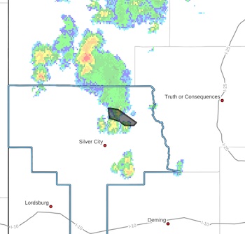
* WHERE...A portion of southwest New Mexico, including the following county, Grant. Specifically over the Trout Fire Burn Scar.
* WHEN...Until 600 PM MDT.
* IMPACTS...Minor flooding in low-lying and poordrainage areas. Rises in small streams and normally dry arroyos.
* ADDITIONAL DETAILS...
- At 254 PM MDT, Doppler radar indicated heavy rain due to
thunderstorms. This will cause arroyo and small stream
flooding. Between 0.5 and 1 inch of rain has fallen.
- Additional rainfall of up to 0.5 to 1 inch is expected over
the area. This additional rain will result in minor flooding.
This flood advisory could be upgraded to a flash flood
warning, so keep aware of current conditions.
- Some locations that may experience flooding include...
Lake Roberts, Hill Canyon, Gattons Park, Three Circle Canyon,
Soldiers Canyon, Meadow Creek, Cottonwood Canyon, Allie
Canyon, Lake Roberts Heights, Trout Valley, Camp Thunderbird,
Sapillo Creek Valley and Upper Mimbres Valley.
- http://www.weather.gov/safety/flood
PRECAUTIONARY/PREPAREDNESS ACTIONS...
Turn around, don't drown when encountering flooded roads. Most flood
deaths occur in vehicles.
Be aware of your surroundings and do not drive on flooded roads.
In hilly terrain there are numerous low water crossings which are
potentially dangerous in heavy rain. Do not attempt to cross flooded
roads. Find an alternate route.


