


 The National Weather Service in El Paso has issued a
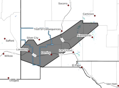
* Dust Storm Warning for...
Central Grant County in southwestern New Mexico...
Northwestern Otero County in south central New Mexico...
Central Sierra County in south central New Mexico...
Luna County in southwestern New Mexico...
Northern Dona Ana County in south central New Mexico...
Northern Hidalgo County in southwestern New Mexico...
* Until 800 PM MDT.
* At 353 PM MDT, wide plumes of blowing dust continued to affect
much of south central New Mexico. Blowing dust will continue
through the evening commute and through sunset.
HAZARD...Less than a quarter mile visibility with strong winds up
to 50 mph.
SOURCE...Detected by National Weather Service meteorologists.
IMPACT...Dangerous life-threatening travel.
* This includes the following highways...
Interstate 10 in New Mexico between mile markers 1 and 109.
Interstate 25 in New Mexico between mile markers 18 and 64.
Highway 54 in New Mexico between mile markers 80 and 100.
Locations impacted include...
Deming, Lordsburg, Hatch, Nutt, Fort Selden State Historic Site,
Macho Springs Wind Farm, Radium Springs, Cotton City, Sierra Blanca
Peak, Derry, Three Rivers, Redrock, Windmill, Upham, Rock Hound
State Park, Salinas Peak, White Signal, Playas.
PRECAUTIONARY/PREPAREDNESS ACTIONS...
Dust storms lead to dangerous driving conditions with visibility
reduced to near zero. If driving, avoid dust storms if possible. If
caught in one, pull off the road, turn off your lights and keep your
foot off the brake.
Motorists should not drive into a dust storm. PULL ASIDE STAY ALIVE!


