


 CRITICAL FIRE DANGER LATE SATURDAY MORNING INTO SATURDAY AFTERNOON WEST OF THE DIVIDE... A cut off low will bringing windy south to southwest winds of 15 to 25 mph with gusts of 35 to 40 mph to the area late Saturday morning through Saturday afternoon. Min RH values in the single digits are in the forecast coupled with gusty winds and very dry fuels which will lead to dangerous fire weather conditions across the Watch area.
...FIRE WEATHER WATCH IN EFFECT FROM MONDAY MORNING THROUGH
MONDAY EVENING FOR STRONG WINDS AND LOW RH VALUES FOR FIRE WEATHER
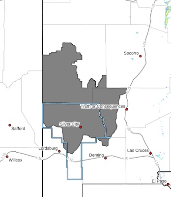
ZONE 110
...FIRE WEATHER WATCH IS CANCELLED FOR SATURDAY FOR FIRE WEATHER
WATCH ZONE 110..
The National Weather Service in El Paso Tx/Santa Teresa has
issued a Fire Weather Watch for strong winds and low RH values,
which is in effect from Monday morning through Monday evening. The
Fire Weather Watch has been cancelled.
* AFFECTED AREA...Fire Weather Zone 110.
* WIND...South to southwest winds 15 to 25 mph with gust of 35
to 40 mph.
* HUMIDITY...7-12 percent.
* EXPERIMENTAL RFTI...5 to 7 on the scale of 0 to 10.
* HIGHEST THREAT...is located along and west of the Continental
Divide.
* IMPACTS...any fires that develop will likely spread rapidly.
Outdoor burning is not recommended.
PRECAUTIONARY/PREPAREDNESS ACTIONS...
A Fire Weather Watch means that critical fire weather conditions
are forecast to occur. Listen for later forecasts and possible
Red Flag Warnings.


