


 Flash Flood Warning
National Weather Service El Paso Tx/Santa Teresa NM
248 PM MDT Sat Aug 2 2025
The National Weather Service in El Paso Tx/Santa Teresa has issued a
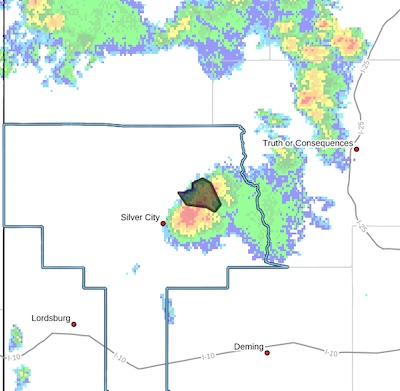
* Flash Flood Warning for...The Trout Fire Burn Scar in... North Central Grant County in southwestern New Mexico...
* Until 500 PM MDT.
* At 248 PM MDT, Doppler radar indicated thunderstorms producing heavy rain over the Trout Fire Burn Scar. Between 0.1 and 0.4
inches of rain have fallen. Additional rainfall amounts up to 0.5 inches are possible in the warned area. Flash flooding is ongoing or expected to begin shortly.
Excessive rainfall over the burn scar will result in debris flow
moving through the Trout Fire Burn Scar, into canyons flowing east
towards the Mimbres River, including Three Circle, Soldiers,
Cottonwood, and Bear Canyons. The Mimbres River will also be
impacted. The debris flow can consist of rock, mud, vegetation and
other loose materials.
HAZARD...Life threatening flash flooding. Thunderstorms
producing flash flooding in and around the Trout Fire
Burn Scar.
SOURCE...Radar.
IMPACT...Life threatening flash flooding of areas in and around
the Trout Fire Burn Scar.
* Some locations that will experience flash flooding include...
Allie Canyon, Bear Canyon, Cottonwood Canyon, Shingle Canyon,
Soldiers Canyon, Mimbres River Preserve, Three Circle Canyon,
Mimbres, Camp Thunderbird and Upper Mimbres Valley.
PRECAUTIONARY/PREPAREDNESS ACTIONS...
This is a life threatening situation. Heavy rainfall will cause
extensive and severe flash flooding of creeks...streams...and
ditches in the Trout Fire Burn Scar. Severe debris flows can also be
anticipated across roads. Roads and driveways may be washed away in
places. If you encounter flood waters...climb to safety.
Be aware of your surroundings and do not drive on flooded roads.


