


 [Editor's Note: Expect more downstream!]
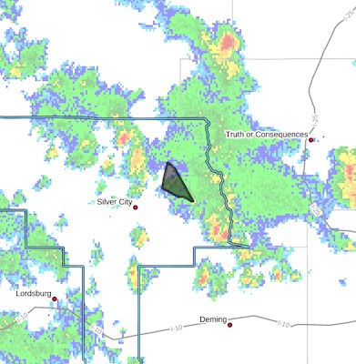
Flash Flood Warning
National Weather Service El Paso Tx/Santa Teresa NM
204 PM MDT Tue Jul 22 2025
The National Weather Service in El Paso Tx/Santa Teresa has issued a
* Flash Flood Warning for...
The east side of the Trout Fire burn scar in...
Northeastern Grant County in southwestern New Mexico...
* Until 430 PM MDT.
* At 204 PM MDT, Doppler radar indicated thunderstorms producing heavy rain over the Trout Fire Burn Scar. Between 0.5 and 1 inch of rain has fallen.
The expected rainfall rate is 0.75 to 1.25
inches in 1 hour. Additional rainfall amounts of 0.5 to 1 inch are
possible in the warned area. Flash flooding is ongoing or expected
to begin shortly.
Excessive rainfall over the burn scar will result in debris flow
moving through the Allie and Soldier canyons, and across Highway 35.
The debris flow can consist of rock, mud, vegetation and other loose
materials.
HAZARD...Flash flooding caused by thunderstorms in and around
the Trout Fire Burn Scar.
SOURCE...Radar.
IMPACT...Flooding of areas in and around the Trout Fire Burn
Scar.
* Some locations that will experience flash flooding include...
San Lorenzo, Allie Canyon, Shingle Canyon, Mimbres River Preserve,
Cottonwood Canyon, Bear Canyon, Soldiers Canyon, Three Circle
Canyon, Gattons Park, Mimbres, Georgetown, Camp Thunderbird and
Upper Mimbres Valley.
PRECAUTIONARY/PREPAREDNESS ACTIONS...
Debris flows can also be anticipated across roads. Roads and
driveways may be washed away in places. If you encounter flood
waters...climb to safety.
Move away from recently burned areas. Life-threatening flooding of
creeks, roads and normally dry arroyos is possible. The heavy rains
may trigger rockslides, mudslides and debris flows in steep terrain,
especially in and around these areas.


