


 Flash Flood Warning
National Weather Service El Paso Tx/Santa Teresa NM
422 PM MDT Tue Aug 12 2025
The National Weather Service in El Paso Tx/Santa Teresa has issued a
* Flash Flood Warning for...
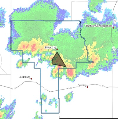
Southeastern Grant County in southwestern New Mexico...
* Until 615 PM MDT.
* At 422 PM MDT, Doppler radar indicated thunderstorms producing heavy rain across the warned area. Between 1.5 and 2 inches of rain have fallen. Flash flooding is ongoing or expected to begin
shortly.
HAZARD...Flash flooding caused by thunderstorms.
SOURCE...Radar.
IMPACT...Flash flooding of small creeks and streams, urban
areas, highways, streets and underpasses as well as
other poor drainage and low-lying areas.
* Some locations that will experience flash flooding include...
Ridge Road south of Silver City, White Signal.
This includes the following streams and drainages...
Arenas, Pinos Altos Creek and Lampbright Draw.
PRECAUTIONARY/PREPAREDNESS ACTIONS...
Turn around, don't drown when encountering flooded roads. Most flood
deaths occur in vehicles.
In hilly terrain there are numerous low water crossings which are
potentially dangerous in heavy rain. Do not attempt to cross flooded
roads. Find an alternate route.


