


 CRITICAL TO EXTREME FIRE WEATHER FOR SOUTHERN NEW MEXICO AND FAR WEST TEXAS ON WEDNESDAY AND THURSDAY... .An upper level trough is expected to swing through the Four Corners on Thursday aligning the jet stream across much of New Mexico. This will develop a lee cyclone over Eastern Colorado while deep mixing taps into higher winds aloft. Windy to very windy conditions will combine with single-digit lowland minimum RH values with only the highest elevations seeing minimum RH values in the teens. When combined with very dry fuels, critical to possibly extreme fire weather conditions are expected for Thursday afternoon. The system will linger into Friday, with windy and dry conditions continuing with very dry fuels and very low Min RH values.
Southwest Deserts and Lowlands/Las Cruces BLM/GLZ-
South Central Lowlands and Southern Rio Grande Valley/BLM/GLZ-
Capitan and Sacramento Mountains/Lincoln NF/LNZ-
Texas Fire Weather Zone 055
El Paso County- Texas Fire Weather Zone 056
Hudspeth County-
428 AM MDT Thu Apr 17 2025
...RED FLAG WARNING REMAINS IN EFFECT FROM 10 AM THIS MORNING TO
9 PM MDT THIS EVENING FOR FOR STRONG WINDS, VERY LOW HUMIDITY,
AND CRITICALLY DRY FUELS FOR SOUTHWEST AND SOUTH CENTRAL NEW
MEXICO, AND FAR WEST TEXAS...
...RED FLAG WARNING IN EFFECT FROM NOON TO 8 PM MDT FRIDAY FOR
STRONG WINDS, VERY LOW HUMIDITY,AND CRITICALLY DRY FUELS FOR
SOUTHWEST AND SOUTH CENTRAL NEW MEXICO AND FAR WEST TEXAS...
The National Weather Service in El Paso Tx/Santa Teresa has
issued a Red Flag Warning, which is in effect from noon to 8 PM
MDT Friday. The Fire Weather Watch is no longer in effect.
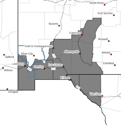
* AFFECTED AREA...Texas fire zones 55 and 56, which includes El
Paso and Hudspeth counties. Also, New Mexico fire zones 110,
111, 112, and 113, which includes Hidalgo, Grant, Luna, Dona
Ana, Sierra, and Otero counties.
* TIMING...From 10 AM MDT to 9 PM MDT on Thursday and from noon
to 8 PM on Friday.
* WINDS...For Thursday, southwest 25 to 35 mph with gusts up to
55 to 65 mph. On Friday, Southwest 20 to 25 mph with gusts 40
to 45 mph.
* RELATIVE HUMIDITY...as 5-10 percent Thursday, 8 to 12 percent
Friday.
* EXPERIMENTAL RFTI...5 to 9 or Critical to Extreme on Thursday.
3 to 7 Elevated to Critical on Friday.
* IMPACTS...any fires that develop will likely spread rapidly.
Outdoor burning is not recommended.
PRECAUTIONARY/PREPAREDNESS ACTIONS...
A Red Flag Warning means that critical fire weather conditions
are either occurring now, or will shortly. A combination of
strong winds, low relative humidity, and warm temperatures can
contribute to extreme fire behavior.


