


 High Fire Danger Continue Today... .Strong southwesterly flow will persist today resulting in winds becoming gusty once again. Winds will increase by the late morning hours on Friday. Relative humidities will remain around 9 to 14 percent in most southern NM and far west Texas zones. The exception will be in the western portions of NM110, where RHs will increase slightly to 16 to 20 percent. However, the eastern slopes of the Black Range will be below 15 percent. Strong winds and dry conditions will continue through the weekend into the first part of next week.
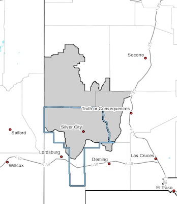
NEW MEXICO FIRE WEATHER ZONE 110
SOUTHWEST MOUNTAINS/GILA NF/APACHE NF/GLZ-
247 AM MST Fri Mar 12 2021
...RED FLAG WARNING IN EFFECT FROM 11 AM THIS MORNING TO 7 PM MST
THIS EVENING FOR DRY AND WINDY CONDITIONS FOR FIRE WEATHER ZONE
110...
The National Weather Service in El Paso Tx/Santa Teresa has
issued a Red Flag Warning, which is in effect from 11 AM this
morning to 7 PM MST this evening.
* AFFECTED AREA...The eastern portions of the Gila Region,
especially over the higher elevations and the eastern slopes of
the Black Range (NM110).
* WIND...Sustained winds from the west-southwest at 20 to 25
mph.Wind gusts of up to 35 mph.
* HUMIDITY...9 to 14 percent.
* IMPACTS...Any fires that develop will likely spread rapidly.
Outdoor burning is not recommended.
PRECAUTIONARY/PREPAREDNESS ACTIONS...
A Red Flag Warning means that critical fire weather conditions
are either occurring now, or will shortly. A combination of
strong winds, low relative humidity, and warm temperatures can
contribute to extreme fire behavior.