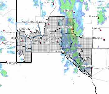
[Editor's Note: I just got SEVEN weather alerts. Some were identical. I will post some of them on the weather page with maps and let YOU figure out which ones pertain to you.  I THINK I got the correct maps with the correct text, but I'm not sure. I give up!}

This one is a wind advisory with extended time and locations. 

wind advisory 3 0213 021523Southern Gila Foothills/Mimbres Valley-
Southwest Desert/Lower Gila River Valley-Lowlands of the Bootheel-
Southwest Desert/Mimbres Basin-Sierra County Lakes-
Northern Dona Ana County-Southern Dona Ana County/Mesilla Valley-
Central Tularosa Basin-Southern Tularosa Basin-Otero Mesa-
Western El Paso County-Eastern/Central El Paso County-
Northern Hudspeth Highlands/Hueco Mountains-Salt Basin-
Southern Hudspeth Highlands-
Rio Grande Valley of Eastern El Paso/Western Hudspeth Counties-
Rio Grande Valley of Eastern Hudspeth County-
Including the cities of Mimbres, Hurley, Faywood,
Grant County Airport, Lordsburg, Red Rock, Virden,
Antelope Wells, Animas, Hachita, Deming, Columbus,
Truth Or Consequences, Derry, Spaceport, Garfield, Hatch,

Radium Springs, Las Cruces, Vado, Sunland Park, Alamogordo,
Tularosa, White Sands National Park, Chaparral, Orogrande,
White Sands Range Headquarters, Crow Flats, Downtown El Paso,
West El Paso, Upper Valley, East and Northeast El Paso, Socorro,
Fort Bliss, Hueco Tanks, Loma Linda, Cornudas, Dell City,
Salt Flat, Sierra Blanca, Fabens, Fort Hancock, Tornillo,
and Indian Hot Springs
158 PM MST Mon Feb 13 2023

...WIND ADVISORY NOW IN EFFECT UNTIL 5 AM MST WEDNESDAY...
...HIGH WIND WATCH IN EFFECT FROM LATE TUESDAY NIGHT THROUGH
WEDNESDAY AFTERNOON...

* WHAT...For the Wind Advisory, southwest winds 25 to 30 mph with
gusts up to 45 mph. For the High Wind Watch, west winds 30 to 40
mph with gusts up to 60 mph possible.

* WHERE...Portions of south central and southwest New Mexico and
southwest Texas.

* WHEN...For the Wind Advisory, until 5 AM MST Wednesday. For
the High Wind Watch, from late Tuesday night through Wednesday
afternoon.

* IMPACTS...Damaging winds could blow down trees and power
lines. Widespread power outages are possible. Travel could be
difficult, especially for high profile vehicles.

* ADDITIONAL DETAILS...West winds will be gusty Tuesday afternoon
ahead of the next storm system. Stronger gusts will be seen on
east slopes during this time. There will be a brief lull Tuesday
evening for areas east of the Rio Grande Valley as a strong cold
front impacts areas west of the Continental Divide. The
strongest winds will be seen along the front as it moves to the
east early Wednesday morning.

PRECAUTIONARY/PREPAREDNESS ACTIONS...

Monitor the latest forecasts and warnings for updates on this
situation. Fasten loose objects or shelter objects in a safe
location prior to the onset of winds.

Content on the Beat

WARNING: All articles and photos with a byline or photo credit are copyrighted to the author or photographer. You may not use any information found within the articles without asking permission AND giving attribution to the source. Photos can be requested and may incur a nominal fee for use personally or commercially.

Disclaimer: If you find errors in articles not written by the Beat team but sent to us from other content providers, please contact the writer, not the Beat. For example, obituaries are always provided by the funeral home or a family member. We can fix errors, but please give details on where the error is so we can find it. News releases from government and non-profit entities are posted generally without change, except for legal notices, which incur a small charge.

NOTE: If an article does not have a byline, it was written by someone not affiliated with the Beat and then sent to the Beat for posting.

Images: We have received complaints about large images blocking parts of other articles. If you encounter this problem, click on the title of the article you want to read and it will take you to that article's page, which shows only that article without any intruders. 

New Columnists: The Beat continues to bring you new columnists. And check out the old faithfuls who continue to provide content.

Newsletter: If you opt in to the Join GCB Three Times Weekly Updates option above this to the right, you will be subscribed to email notifications with links to recently posted articles.

Submitting to the Beat

Those new to providing news releases to the Beat are asked to please check out submission guidelines at https://www.grantcountybeat.com/about/submissions. They are for your information to make life easier on the readers, as well as for the editor.

Advertising: Don't forget to tell advertisers that you saw their ads on the Beat.

Classifieds: We have changed Classifieds to a simpler option. Check periodically to see if any new ones have popped up. Send your information to editor@grantcountybeat.com and we will post it as soon as we can. Instructions and prices are on the page.

Editor's Notes

It has come to this editor's attention that people are sending information to the Grant County Beat Facebook page. Please be aware that the editor does not regularly monitor the page. If you have items you want to send to the editor, please send them to editor@grantcountybeat.com. Thanks!

Here for YOU: Consider the Beat your DAILY newspaper for up-to-date information about Grant County. It's at your fingertips! One Click to Local News. Thanks for your support for and your readership of Grant County's online news source—www.grantcountybeat.com

Feel free to notify editor@grantcountybeat.com if you notice any technical problems on the site. Your convenience is my desire for the Beat.  The Beat totally appreciates its readers and subscribers!  

Compliance: Because you are an esteemed member of The Grant County Beat readership, be assured that we at the Beat continue to do everything we can to be in full compliance with GDPR and pertinent US law, so that the information you have chosen to give to us cannot be compromised.