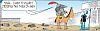
Wizard of ID Comic for August 2, 2025
BY: Mick Mastroianni and Johnny Hart
 Click to Search
[{{{type}}}] {{{reason}}}
{{/data.error.root_cause}}
{{{_source.displayDate}}}
{{/_source.showDate}}{{{_source.description}}}
{{#_source.additionalInfo}}{{#_source.additionalFields}} {{#title}} {{{label}}}: {{{title}}} {{/title}} {{/_source.additionalFields}}
{{/_source.additionalInfo}}
You'll receive the Update on Monday, Wednesday, and Friday.

By Lynn Janes
The town of Bayard held a regular meeting July 16, 2025. Attendance included Mayor John L. Ojinaga, Mayor Pro Tem Eloy Medina and Councilors, Frances Gonzales, Eloy Gonzales and Gilbert Ortiz. Martha Salas, city clerk, also attended.
The council approved the consent agenda that included minutes, accounts payable and department head reports. It also approved attendance of elected officials to attend a conference of the New Mexico Municipal league and the head librarian to attend an annual conference.
Old business
By Lynn Janes
On July 31, 2025, the board of regents held a special meeting at Western New Mexico University. The board consisted of Chair Steven Neville, Joseph "Dean" Reed, John Wertheim and WNMU Student Regent Keana Huerta. Dr. Chris Maples, interim president, also attended.
The board approved the agenda with the removal of the agenda item that pertained to the early childhood facility. Reed said they needed more information. They also approved the minutes from the last several meetings.
Neville introduced the new interim president for the president's report. Maples had officially started June 29, 2025. Neville asked if he had anything to report or comments to make.
Lightning-caused fires suppressed; Trout Fire closure lifted
Silver City, NM, Aug. 1, 2025— The Trout Fire was 100% contained on July 24 and the associated area closure was lifted as of Thursday, July 31. The public should be aware of hazards that exist within the burned area, including stump holes and loosened soil, rolling rocks, logs, and other debris, fire-weakened trees, and roads or trails that may be impassable due to fallen trees or flood impacts. There is potential for flash flooding within the burned area, especially where soil and vegetation burned at higher intensity. The forest road crew will be working on area roads over the next couple of weeks.
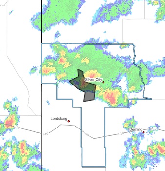
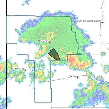 Flash Flood Warning
National Weather Service El Paso Tx/Santa Teresa NM
721 PM MDT Thu Jul 31 2025
The National Weather Service in El Paso Tx/Santa Teresa has issued a
* Flash Flood Warning for...
Central Grant County in southwestern New Mexico...
* Until 915 PM MDT.
* At 721 PM MDT, Doppler radar indicated thunderstorms producing heavy rain across the warned area. Between 1 and 2 inches of rain have fallen. Additional rainfall amounts up to 1 inch are possible
in the warned area. Flash flooding is ongoing or expected to begin shortly.
{Editor's Note: For location and Zoom or listening availability, please visit https://www.grantcountybeat.com/news/news-releases/game-commission-to-meet-aug-15-2025 }
The New Mexico Department of Game and Fish Commission Meeting will take place August 15th, in Reserve, NM, starting at 9 A.M. Location not yet announced.
The item on the agenda is the discussion of the Mexican Wolf introduction program, which has been contentious for years.
The Mexican Gray Wolf was listed on the Federal Endangered Species list in 1976, with the goal of reaching 100 wolves before it might be eligible for delisting. However, the wolf has remained on the list even though it reached the 100 level several years ago. At that point, the goal was raised to 200, which it has now attained, and it has been raised to more than 300 as a goal.
Guess what, readers? It's raining. It's monsoon season. If you live in or are driving in a low lying area, be aware that floods can occur with water from upstream. Please be aware and careful!
 FLOOD ADVISORY IN EFFECT UNTIL 9 PM MDT THIS EVENING...
* WHAT...Flooding caused by excessive rainfall is expected.
* WHERE...A portion of southwest New Mexico, including the following county, Grant.
* WHEN...Until 900 PM MDT.
* IMPACTS...Minor flooding in low-lying and poor drainage areas. Some low-water crossings may become impassable.
* ADDITIONAL DETAILS...
- At 658 PM MDT, Doppler radar indicated heavy rain due to thunderstorms. Minor flooding is ongoing or expected to begin shortly in the advisory area. Up to 1.5 inches of rain have fallen.
Page 1 of 168


WARNING: All articles and photos with a byline or photo credit are copyrighted to the author or photographer. You may not use any information found within the articles without asking permission AND giving attribution to the source. Photos can be requested and may incur a nominal fee for use personally or commercially.
Disclaimer: If you find errors in articles not written by the Beat team but sent to us from other content providers, please contact the writer, not the Beat. For example, obituaries are always provided by the funeral home or a family member. We can fix errors, but please give details on where the error is so we can find it. News releases from government and non-profit entities are posted generally without change, except for legal notices, which incur a small charge.
NOTE: If an article does not have a byline, it was written by someone not affiliated with the Beat and then sent to the Beat for posting.
Images: We have received complaints about large images blocking parts of other articles. If you encounter this problem, click on the title of the article you want to read and it will take you to that article's page, which shows only that article without any intruders.
New Columnists: The Beat continues to bring you new columnists. And check out the old faithfuls who continue to provide content.
Newsletter: If you opt in to the Join GCB Three Times Weekly Updates option above this to the right, you will be subscribed to email notifications with links to recently posted articles.
It has come to this editor's attention that people are sending information to the Grant County Beat Facebook page. Please be aware that the editor does not regularly monitor the page. If you have items you want to send to the editor, please send them to editor@grantcountybeat.com. Thanks!
Here for YOU: Consider the Beat your DAILY newspaper for up-to-date information about Grant County. It's at your fingertips! One Click to Local News. Thanks for your support for and your readership of Grant County's online news source—www.grantcountybeat.com
Feel free to notify editor@grantcountybeat.com if you notice any technical problems on the site. Your convenience is my desire for the Beat. The Beat totally appreciates its readers and subscribers!
Compliance: Because you are an esteemed member of The Grant County Beat readership, be assured that we at the Beat continue to do everything we can to be in full compliance with GDPR and pertinent US law, so that the information you have chosen to give to us cannot be compromised.
Those new to providing news releases to the Beat are asked to please check out submission guidelines at https://www.grantcountybeat.com/about/submissions. They are for your information to make life easier on the readers, as well as for the editor.
Advertising: Don't forget to tell advertisers that you saw their ads on the Beat.
Classifieds: We have changed Classifieds to a simpler option. Check periodically to see if any new ones have popped up. Send your information to editor@grantcountybeat.com and we will post it as soon as we can. Instructions and prices are on the page.