

 Click to Search
Search
[{{{type}}}] {{{reason}}}
{{/data.error.root_cause}}
{{{_source.title}}} {{#_source.showPrice}} {{{_source.displayPrice}}} {{/_source.showPrice}}
{{#_source.showLink}} {{/_source.showLink}} {{#_source.showDate}}{{{_source.displayDate}}}
{{/_source.showDate}}{{{_source.description}}}
{{#_source.additionalInfo}}{{#_source.additionalFields}} {{#title}} {{{label}}}: {{{title}}} {{/title}} {{/_source.additionalFields}}
{{/_source.additionalInfo}}
Weather
- Category: Weather
 CRITICAL FIRE CONDITIONS FOR SOUTHERN NEW MEXICO AND WEST TEXAS ON TUESDAY... Strong jet stream flow aloft crossing the Southern Rockies will induce a deep 980-mb surface low over the Central Plains today. Strong west-southwest winds across New Mexico and west Texas are expected through the afternoon and evening hours with sustained 20-ft speeds 25 to 35 mph and gusts as high as 60 mph. Relative humidity continues to be dry, falling below 15% in the desert lowlands and 15 to 25% in the National Forests. Mountain zones are included in the warning given unseasonably dry fuels and ongoing severe drought conditions. Latest ERCs are near the 90th- percentile. Any fires that start have the potential to spread rapidly. Breezy winds will continue on Wednesday on the backside of the system but not as strong. Winds will top out around 20 to 25 MPH while minimum relative humidity values drop to the lower to mid teens in the lowlands. Mountains will see higher minimum relative humidity values and ERCs
- Category: Weather
ROAD CLOSURE in Deming
NM 549 is closed at milepost 0 to milepost 18 due to high winds and zero visibility, all traffic being diverted into Deming. Shelter in place locations are the Deming Learning Center, 5R Truck Stop, Deming Truck Stop, Deming Soccer Fields. The NMDOT will continue monitoring the roadway. This event will be updated as conditions change.
- Category: Weather
DIFFICULT DRIVING CONDITIONS in Deming to Akela
Difficult Driving Conditions, I 10 eastbound and westbound from mile marker 81, (DEMING WEST) to mile marker 102, (AKELA) use caution due to high winds and zero visibility. This event will be updated as conditions change.
ROAD CLOSURE in Deming to Akela
Closure, I 10 eastbound and westbound from mile marker 81, (DEMING WEST) to mile marker 102, (AKELA) is closed due to high winds and zero visibility, all traffic being diverted into Deming. This event will be updated as conditions change.
Shelter in place locations are the Deming Learning Center, 5R Truck Stop, Deming Truck Stop, Deming Soccer Fields.
DIFFICULT DRIVING CONDITIONS from Deming to AkelaDifficult Driving Conditions, I 10 eastbound and westbound from mile marker 94, 9 miles east of Deming to mile marker 102, (AKELA), use caution, high winds, and areas of limited visibility due to blowing dust. The NMDOT will continue monitoring the roadway. This event will be updated as conditions change.
- Category: Weather
HIGH WIND WEATHER ADVISORY:
Weather Advisory exist throughout Hidalgo and Luna Counties, visibility is low in areas due to blowing dust. High profile vehicles please use caution. The NMDOT will continue monitoring the roadway. This event will be updated as conditions change.
- Category: Weather
By Mary Alice Murphy
MAPS below
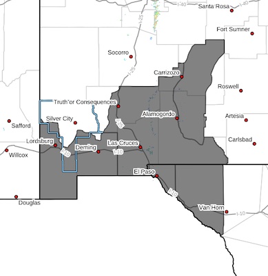
Dear readers, I refuse to post EIGHT MORE alerts with EIGHT different maps for Tuesday, April 1, 2025.
I'm starting to wonder if it's an April Fool's joke, but in case it isn't, I'm telling you where you should watch out for bad weather.
It ranges all over southwest New Mexico, covering the entirety of Grant County and then from the border with Arizona down into Texas as far south as Van Horn, east to eastward of Alamogordo, and north to Carrizoso. It includes Truth or Consequences, Las Cruces, Silver City, Deming Lordsburg and everything in between.


Content on the Beat
WARNING: All articles and photos with a byline or photo credit are copyrighted to the author or photographer. You may not use any information found within the articles without asking permission AND giving attribution to the source. Photos can be requested and may incur a nominal fee for use personally or commercially.
Disclaimer: If you find errors in articles not written by the Beat team but sent to us from other content providers, please contact the writer, not the Beat. For example, obituaries are always provided by the funeral home or a family member. We can fix errors, but please give details on where the error is so we can find it. News releases from government and non-profit entities are posted generally without change, except for legal notices, which incur a small charge.
NOTE: If an article does not have a byline, it was written by someone not affiliated with the Beat and then sent to the Beat for posting.
Images: We have received complaints about large images blocking parts of other articles. If you encounter this problem, click on the title of the article you want to read and it will take you to that article's page, which shows only that article without any intruders.
New Columnists: The Beat continues to bring you new columnists. And check out the old faithfuls who continue to provide content.
Newsletter: If you opt in to the Join GCB Three Times Weekly Updates option above this to the right, you will be subscribed to email notifications with links to recently posted articles.
Editor's Notes
It has come to this editor's attention that people are sending information to the Grant County Beat Facebook page. Please be aware that the editor does not regularly monitor the page. If you have items you want to send to the editor, please send them to editor@grantcountybeat.com. Thanks!
Here for YOU: Consider the Beat your DAILY newspaper for up-to-date information about Grant County. It's at your fingertips! One Click to Local News. Thanks for your support for and your readership of Grant County's online news source—www.grantcountybeat.com
Feel free to notify editor@grantcountybeat.com if you notice any technical problems on the site. Your convenience is my desire for the Beat. The Beat totally appreciates its readers and subscribers!
Compliance: Because you are an esteemed member of The Grant County Beat readership, be assured that we at the Beat continue to do everything we can to be in full compliance with GDPR and pertinent US law, so that the information you have chosen to give to us cannot be compromised.
Submitting to the Beat
Those new to providing news releases to the Beat are asked to please check out submission guidelines at https://www.grantcountybeat.com/about/submissions. They are for your information to make life easier on the readers, as well as for the editor.
Advertising: Don't forget to tell advertisers that you saw their ads on the Beat.
Classifieds: We have changed Classifieds to a simpler option. Check periodically to see if any new ones have popped up. Send your information to editor@grantcountybeat.com and we will post it as soon as we can. Instructions and prices are on the page.