

 Click to Search
Search
[{{{type}}}] {{{reason}}}
{{/data.error.root_cause}}
{{{_source.title}}} {{#_source.showPrice}} {{{_source.displayPrice}}} {{/_source.showPrice}}
{{#_source.showLink}} {{/_source.showLink}} {{#_source.showDate}}{{{_source.displayDate}}}
{{/_source.showDate}}{{{_source.description}}}
{{#_source.additionalInfo}}{{#_source.additionalFields}} {{#title}} {{{label}}}: {{{title}}} {{/title}} {{/_source.additionalFields}}
{{/_source.additionalInfo}}
Weather
- Category: Weather
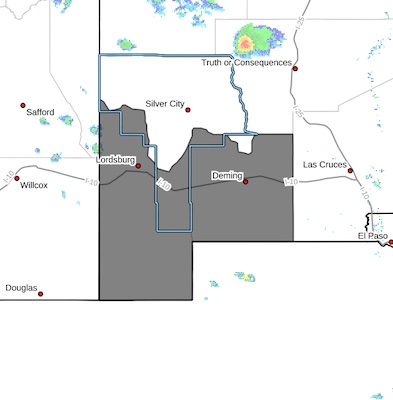
HIGH WIND WEATHER ADVISORY:
High wind warning in Hildago, Dona Ana and Luna Counties, visibility is low in areas due to blowing dust. High profile vehicles please use caution. The NMDOT will continue monitoring the roadway. This event will be updated as conditions change.
- Category: Weather
[Editor's Note: Be aware that as the winds die down overnight, most roads will open or perhaps continue as difficult]
NM 9 is now open from Colum us to Santa Teresa, removed from NM Roads.
DIFFICULT DRIVING CONDITIONS Deming to Las Cruces
Difficult Driving Conditions, I 10 westbound and eastbound lanes from mile marker 81, (DEMING WEST) to mile marker 132, 3 miles west of Las Cruces due to dust and high winds.
DIFFICULT DRIVING CONDITIONS Deming to Akela
Difficult Driving Conditions, NM 549 eastbound and westbound lanes from mile marker 0 to mile marker 31 areclosed due to dust and high winds.
DIFFICULT DRIVING CONDITIONS I-10 Arizona Stateline to Deming
Difficult Driving Conditions, I 10 westbound and eastbound lanes from mile marker 5, (NM 80/ROAD FORKS) to mile marker 81, (DEMING WEST) due to dust and high winds, roadways are impassable.
OPEN I-10 to Rodeo
NM 80 is now open, removed from NM Roads.
I-10 to Animas
NM 338 is now open, removed from NM Roads.
DIFFICULT DRIVING CONDITIONS Deming to Hatch
Difficult Driving Conditions, NM 26 eastbound from mile marker 0 to mile marker 44, 3 miles west of Hatch due to dust and high winds.
DIFFICULT DRIVING CONDITIONS Deming to Silver City
Difficult Driving Conditions, US 180 eastbound and westbound from mile marker 164, Deming to mile marker 133, 3 miles west of Whitewater due to dust and high winds.
- Category: Weather
Difficult Driving Conditions, I 10 eastbound and westbound from mile marker 94, 9 miles east of Deming to mile marker 100, 15 miles east of Deming. High Winds - High profile vehicles use extreme caution. Blowing dust may cause limited visibility.
- Category: Weather
High wind warning in Hildago, Dona Ana and Luna Counties, visibility is low in areas due to blowing dust. High profile vehicles please use caution. The NMDOT will continue monitoring the roadway. This event will be updated as conditions change.
- Category: Weather
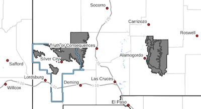
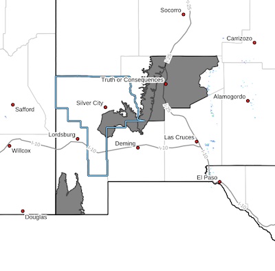
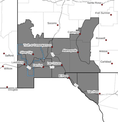 [Editor's Note: This editor is rebelling against resizing four different slightly varying maps, changing the format, saving them and then adding them to the various predictions.]
Basically the predictions are wind advisories, high wind warnings and/or blowing dust advisories with winds 25-35 mph with gusts to 50 mph or 55 mph.
...ADVISORY or WARNNG REMAINS IN EFFECT FROM NOON TODAY TO 8 PM MDT THIS
EVENING...
...DITTO IN EFFECT FROM NOON TO 8 PM MDT WEDNESDAY...
* WHAT...West winds 25 to 35 mph with gusts up to 50 mph or 55 mph expected both today and Wednesday.
* WHERE... wherever you live on this map. You know what to expect!
- Category: Weather
 West Slopes Sacramento Mountains Below 7500 Feet-Sacramento
Mountains Above 7500 Feet-East Slopes Sacramento Mountains Below
7500 Feet-Southern Gila Region Highlands/Black Range-
Including the cities of Cloudcroft, Kingston, Timberon,
Mescalero, Sacramento, Pinon, Apache Summit, Mayhill, Lake
Roberts, Mountain Park, and Sunspot
103 PM MDT Mon May 12 2025
- Category: Weather
 Southern Gila Foothills/Mimbres Valley-Uplands of the Bootheel- Eastern Black Range Foothills-Sierra County Lakes- Including the cities of Grant County Airport, Truth Or Consequences, Faywood, Derry, Winston, Hurley, Hillsboro,
Spaceport, and Cloverdale
103 PM MDT Mon May 12 2025
...WIND ADVISORY IN EFFECT FROM NOON TO 8 PM MDT TUESDAY...
* WHAT...West winds 30 to 40 mph with gusts up to 55 mph expected.
* WHERE...Sierra County Lakes, Eastern Black Range Foothills,
Southern Gila Foothills/Mimbres Valley, and Uplands of the
Bootheel.
- Category: Weather
 EXTENDED DURATION OF CRITICAL TO EXTREME FIRE WEATHER CONDITIONS AREAWIDE MONDAY THROUGH WEDNESDAY... .An approaching Pacific low pressure system moving into the Great Basin will induce strong winds across the Desert Southwest Tuesday and Wednesday. The region will continue quite dry with minimum RH in the single digits and very poor overnight recovery. Warmer than average temperatures will also persist, leading to deep mixing and instability. West to southwest winds will increase to 25 to 35 mph with gust 40 to 50 mph common in the afternoon both days. Area mountains will see slightly stronger winds, and higher gusts. Fire weather conditions will become Critical to Extreme each day across all of Southern New Mexico and far west Texas.
Southwest Deserts and Lowlands/Las Cruces BLM/GLZ-
258 PM MDT Mon May 12 2025


Content on the Beat
WARNING: All articles and photos with a byline or photo credit are copyrighted to the author or photographer. You may not use any information found within the articles without asking permission AND giving attribution to the source. Photos can be requested and may incur a nominal fee for use personally or commercially.
Disclaimer: If you find errors in articles not written by the Beat team but sent to us from other content providers, please contact the writer, not the Beat. For example, obituaries are always provided by the funeral home or a family member. We can fix errors, but please give details on where the error is so we can find it. News releases from government and non-profit entities are posted generally without change, except for legal notices, which incur a small charge.
NOTE: If an article does not have a byline, it was written by someone not affiliated with the Beat and then sent to the Beat for posting.
Images: We have received complaints about large images blocking parts of other articles. If you encounter this problem, click on the title of the article you want to read and it will take you to that article's page, which shows only that article without any intruders.
New Columnists: The Beat continues to bring you new columnists. And check out the old faithfuls who continue to provide content.
Newsletter: If you opt in to the Join GCB Three Times Weekly Updates option above this to the right, you will be subscribed to email notifications with links to recently posted articles.
Editor's Notes
It has come to this editor's attention that people are sending information to the Grant County Beat Facebook page. Please be aware that the editor does not regularly monitor the page. If you have items you want to send to the editor, please send them to editor@grantcountybeat.com. Thanks!
Here for YOU: Consider the Beat your DAILY newspaper for up-to-date information about Grant County. It's at your fingertips! One Click to Local News. Thanks for your support for and your readership of Grant County's online news source—www.grantcountybeat.com
Feel free to notify editor@grantcountybeat.com if you notice any technical problems on the site. Your convenience is my desire for the Beat. The Beat totally appreciates its readers and subscribers!
Compliance: Because you are an esteemed member of The Grant County Beat readership, be assured that we at the Beat continue to do everything we can to be in full compliance with GDPR and pertinent US law, so that the information you have chosen to give to us cannot be compromised.
Submitting to the Beat
Those new to providing news releases to the Beat are asked to please check out submission guidelines at https://www.grantcountybeat.com/about/submissions. They are for your information to make life easier on the readers, as well as for the editor.
Advertising: Don't forget to tell advertisers that you saw their ads on the Beat.
Classifieds: We have changed Classifieds to a simpler option. Check periodically to see if any new ones have popped up. Send your information to editor@grantcountybeat.com and we will post it as soon as we can. Instructions and prices are on the page.