

 Click to Search
Search
[{{{type}}}] {{{reason}}}
{{/data.error.root_cause}}
{{{_source.title}}} {{#_source.showPrice}} {{{_source.displayPrice}}} {{/_source.showPrice}}
{{#_source.showLink}} {{/_source.showLink}} {{#_source.showDate}}{{{_source.displayDate}}}
{{/_source.showDate}}{{{_source.description}}}
{{#_source.additionalInfo}}{{#_source.additionalFields}} {{#title}} {{{label}}}: {{{title}}} {{/title}} {{/_source.additionalFields}}
{{/_source.additionalInfo}}
Weather
- Category: Weather
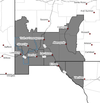
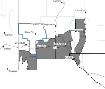 Lowlands of the Bootheel-Southwest Desert/Mimbres Basin-
Northern Dona Ana County-Southern Dona Ana County/Mesilla Valley-
East Central Tularosa Basin/Alamogordo-Southeast Tularosa Basin-
Western El Paso County-Eastern/Central El Paso County-
Including the cities of Antelope Wells, Animas, Hachita, Deming,
Columbus, Garfield, Hatch, Radium Springs, Las Cruces, Vado,
Sunland Park, Alamogordo, Tularosa, Holloman AFB, Orogrande,
Downtown El Paso, West El Paso, Upper Valley,
East and Northeast El Paso, Socorro, and Fort Bliss
429 AM MDT Thu Apr 17 2025
- Category: Weather
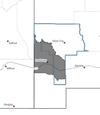 Southwest Desert/Lower Gila River Valley-
Including the cities of Lordsburg, Red Rock, and Virden
429 AM MDT Thu Apr 17 2025
...BLOWING DUST ADVISORY REMAINS IN EFFECT FROM 11 AM THIS
MORNING TO 8 PM MDT THIS EVENING...
...WIND ADVISORY REMAINS IN EFFECT FROM NOON TODAY TO 8 PM MDT
THIS EVENING...
...BLOWING DUST ADVISORY IN EFFECT FROM 11 AM TO 8 PM MDT
FRIDAY...
* WHAT...For the Blowing Dust Advisory, visibility between one-quarter and one mile in blowing dust expected. For the WindAdvisory, southwest winds 30 to 40 mph with gusts to 50 mph.
- Category: Weather
 CRITICAL TO EXTREME FIRE WEATHER FOR SOUTHERN NEW MEXICO AND FAR WEST TEXAS ON WEDNESDAY AND THURSDAY... .An upper level trough is expected to swing through the Four Corners on Thursday aligning the jet stream across much of New Mexico. This will develop a lee cyclone over Eastern Colorado while deep mixing taps into higher winds aloft. Windy to very windy conditions will combine with single-digit lowland minimum RH values with only the highest elevations seeing minimum RH values in the teens. When combined with very dry fuels, critical to possibly extreme fire weather conditions are expected for Thursday afternoon. The system will linger into Friday, with windy and dry conditions continuing with very dry fuels and very low Min RH values.
- Category: Weather
Expect Strong Winds and Blowing Dust
[Editor's Note: Due to an all-day outage of The Beat, this will replace the six weather notices we received, which said which areas would be impacted. If you have been following the weather for a while, you should be able to determine where dust will blow, and where high winds make cause problems. Adjust accordingly!]
Travel advisories have been issued for Thursday, April 17, 2025, with the highest impact for strong winds and blowing dust from noon to 6 p.m. in Southern New Mexico.
The National Weather Service has forecasted sustained wind speeds of 25 to 35 mph and peak gusts up to 65 mph.
- Category: Weather
High winds, severe fire conditions could prompt Public Safety Power Shutoff in parts of New Mexico Thursday
(Albuquerque, NM) – With sustained strong winds and low humidity in the forecast this week, PNM is reminding all of its customers to be prepared for possible weather-related power outages through Thursday.
The National Weather Service has Red Flag Warnings in several parts of the state due to increased wildfire risk. In response, PNM is changing settings on parts of its system to reduce the risk of power lines igniting a wildfire.
- Category: Weather
 CRITICAL TO EXTREME FIRE WEATHER FOR SOUTHERN NEW MEXICO AND FAR WEST TEXAS ON WEDNESDAY AND THURSDAY... .An upper level trough is expected to swing through the Four Corners on Thursday aligning the jet stream across much of New Mexico. This will develop a lee cyclone over Eastern Colorado while deep mixing taps into higher winds aloft. Windy to very windy conditions will combine with single-digit lowland minimum RH values with only the highest elevations seeing minimum RH values in the teens. When combined with very dry fuels, critical to possibly extreme fire weather conditions are expected for Thursday afternoon.
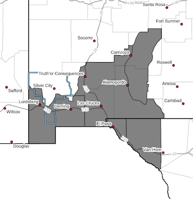
Southwest Mountains/Gila NF/Apache NF/GLZ-
Southwest Deserts and Lowlands/Las Cruces BLM/GLZ-
205 PM MDT Tue Apr 15 2025
...RED FLAG WARNING IN EFFECT FROM NOON TO 8 PM MDT WEDNESDAY FOR
BREEZY WINDS, LOW HUMIDITY, AND CRITICALLY DRY FUELS FOR
SOUTHWESTERN NEW MEXICO...
- Category: Weather
 CRITICAL TO EXTREME FIRE WEATHER FOR SOUTHERN NEW MEXICO AND FAR WEST TEXAS ON THURSDAY... .An upper level trough is expected to swing through the Four Corners on Thursday aligning the jet stream across much of New Mexico. This will develop a lee cyclone over Eastern Colorado while deep mixing taps into higher winds aloft. Windy to very windy conditions will combine with single-digit lowland minimum RH values with only the highest elevations seeing minimum RH values in the teens. When combined with very dry fuels, critical to possibly extreme fire weather conditions are expected for Thursday afternoon.
Southwest Mountains/Gila NF/Apache NF/GLZ-
Southwest Deserts and Lowlands/Las Cruces BLM/GLZ-
South Central Lowlands and Southern Rio Grande Valley/BLM/GLZ-
- Category: Weather
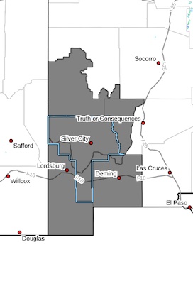
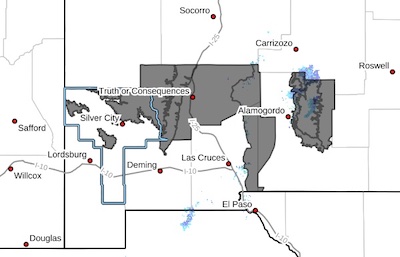 Eastern Black Range Foothills-Sierra County Lakes-West Slopes
Sacramento Mountains Below 7500 Feet-Sacramento Mountains Above
7500 Feet-East Slopes Sacramento Mountains Below 7500 Feet-
Southern Gila Region Highlands/Black Range-West Central Tularosa
Basin/White Sands-
Including the cities of Lake Roberts, Timberon, Sunspot,
Mescalero, White Sands National Park, Spaceport, Chaparral,
Apache Summit, Truth Or Consequences, Derry, Mountain Park,
Kingston, Mayhill, Sacramento, Pinon, Hillsboro, Cloudcroft,
White Sands Range Headquarters, and Winston


Content on the Beat
WARNING: All articles and photos with a byline or photo credit are copyrighted to the author or photographer. You may not use any information found within the articles without asking permission AND giving attribution to the source. Photos can be requested and may incur a nominal fee for use personally or commercially.
Disclaimer: If you find errors in articles not written by the Beat team but sent to us from other content providers, please contact the writer, not the Beat. For example, obituaries are always provided by the funeral home or a family member. We can fix errors, but please give details on where the error is so we can find it. News releases from government and non-profit entities are posted generally without change, except for legal notices, which incur a small charge.
NOTE: If an article does not have a byline, it was written by someone not affiliated with the Beat and then sent to the Beat for posting.
Images: We have received complaints about large images blocking parts of other articles. If you encounter this problem, click on the title of the article you want to read and it will take you to that article's page, which shows only that article without any intruders.
New Columnists: The Beat continues to bring you new columnists. And check out the old faithfuls who continue to provide content.
Newsletter: If you opt in to the Join GCB Three Times Weekly Updates option above this to the right, you will be subscribed to email notifications with links to recently posted articles.
Editor's Notes
It has come to this editor's attention that people are sending information to the Grant County Beat Facebook page. Please be aware that the editor does not regularly monitor the page. If you have items you want to send to the editor, please send them to editor@grantcountybeat.com. Thanks!
Here for YOU: Consider the Beat your DAILY newspaper for up-to-date information about Grant County. It's at your fingertips! One Click to Local News. Thanks for your support for and your readership of Grant County's online news source—www.grantcountybeat.com
Feel free to notify editor@grantcountybeat.com if you notice any technical problems on the site. Your convenience is my desire for the Beat. The Beat totally appreciates its readers and subscribers!
Compliance: Because you are an esteemed member of The Grant County Beat readership, be assured that we at the Beat continue to do everything we can to be in full compliance with GDPR and pertinent US law, so that the information you have chosen to give to us cannot be compromised.
Submitting to the Beat
Those new to providing news releases to the Beat are asked to please check out submission guidelines at https://www.grantcountybeat.com/about/submissions. They are for your information to make life easier on the readers, as well as for the editor.
Advertising: Don't forget to tell advertisers that you saw their ads on the Beat.
Classifieds: We have changed Classifieds to a simpler option. Check periodically to see if any new ones have popped up. Send your information to editor@grantcountybeat.com and we will post it as soon as we can. Instructions and prices are on the page.