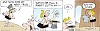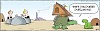
Wizard of ID Comic for July 2, 2025
BY: Mick Mastroianni and Johnny Hart
 Click to Search
[{{{type}}}] {{{reason}}}
{{/data.error.root_cause}}
{{{_source.displayDate}}}
{{/_source.showDate}}{{{_source.description}}}
{{#_source.additionalInfo}}{{#_source.additionalFields}} {{#title}} {{{label}}}: {{{title}}} {{/title}} {{/_source.additionalFields}}
{{/_source.additionalInfo}}
You'll receive the Update on Monday, Wednesday, and Friday.

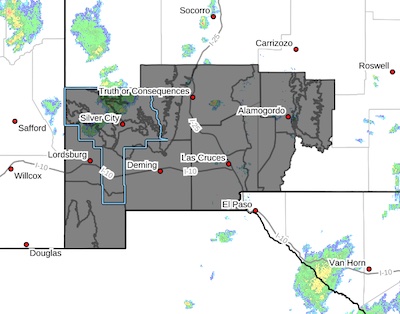 Upper Gila River Valley-Southern Gila Foothills/Mimbres Valley-
Southwest Desert/Lower Gila River Valley-Lowlands of the Bootheel-
Uplands of the Bootheel-Southwest Desert/Mimbres Basin-Eastern
Black Range Foothills-Sierra County Lakes-Northern Dona Ana County-Southern Dona Ana County/Mesilla Valley-West Slopes
Sacramento Mountains Below 7500 Feet-Sacramento Mountains Above 7500 Feet-East Slopes Sacramento Mountains Below 7500 Feet-
Central Grant County/Silver City Area-Southern Gila Region Highlands/Black Range-West Central Tularosa Basin/White Sands-
Upper Gila River Valley-Southern Gila Foothills/Mimbres Valley-
Southwest Desert/Lower Gila River Valley-Lowlands of the Bootheel-
Uplands of the Bootheel-Southwest Desert/Mimbres Basin-Eastern
Black Range Foothills-Sierra County Lakes-Northern Dona Ana
County-Southern Dona Ana County/Mesilla Valley-West Slopes Sacramento Mountains Below 7500 Feet-Sacramento Mountains Above
7500 Feet-East Slopes Sacramento Mountains Below 7500 Feet- Central Grant County/Silver City Area-Southern Gila Region/Highlands/Black Range-West Central Tularosa Basin/White Sands-
Difficult Driving Conditions - Lordsburg
Difficult Driving Conditions, I 10 eastbound and westbound from mile marker 13, (Buena Vista) to mile marker 15, (GARY).High Winds - High profile vehicles use extreme caution. Blowing dust may cause limited visibility.
HIGH WIND WEATHER ADVISORY:
High wind warning in Hildago County, visibility is low in areas due to blowing dust. High profile vehicles please use caution. The NMDOT will continue monitoring the roadway. This event will be updated as conditions change.
Gila Las Cruces Type 3 Incident Management Team MARCUS CORNWELL – INCIDENT COMMANDER
Notification for Public Health and Safety
Tuesday, July 1, 2025
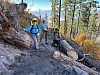
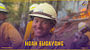
Firefighters suppress fire activity on the southwest edge of the Trout Fire
Acres: 47,294 Start Date: Thursday, June 12, 2025 Location: 12 miles north of Silver City, NM
Personnel: 316 Containment: 83% Cause: Lightning
Summary: On Monday, the Trout Fire experienced increased fire activity on the southwest portion of the perimeter, south of Signal Peak. Ground crews, with support of a Type 1 helicopter conducting water drops, swiftly engaged in suppression actions. The fire activity remained inside existing retardant lines. Additional crews will be assigned to the area with increased fire activity to aid in the suppression efforts. If weather conditions permit, aircraft will support firefighters on the ground.
DIFFICULT DRIVING CONDITIONS Deming Area
Difficult Driving Conditions, in the Deming area, roadways are flooded and low water crossings are running.
May be standing water on roadway. Use extreme caution.
DIFFICULT DRIVING CONDITIONS Hatch Area
Difficult Driving Conditions, in the Hatch area, roadways are flooded and low water crossings are running. The NMDOT is in route to clear.
Standing water on roadway. Use extreme caution.
HIGH WIND WEATHER ADVISORY:
Page 1 of 143


WARNING: All articles and photos with a byline or photo credit are copyrighted to the author or photographer. You may not use any information found within the articles without asking permission AND giving attribution to the source. Photos can be requested and may incur a nominal fee for use personally or commercially.
Disclaimer: If you find errors in articles not written by the Beat team but sent to us from other content providers, please contact the writer, not the Beat. For example, obituaries are always provided by the funeral home or a family member. We can fix errors, but please give details on where the error is so we can find it. News releases from government and non-profit entities are posted generally without change, except for legal notices, which incur a small charge.
NOTE: If an article does not have a byline, it was written by someone not affiliated with the Beat and then sent to the Beat for posting.
Images: We have received complaints about large images blocking parts of other articles. If you encounter this problem, click on the title of the article you want to read and it will take you to that article's page, which shows only that article without any intruders.
New Columnists: The Beat continues to bring you new columnists. And check out the old faithfuls who continue to provide content.
Newsletter: If you opt in to the Join GCB Three Times Weekly Updates option above this to the right, you will be subscribed to email notifications with links to recently posted articles.
It has come to this editor's attention that people are sending information to the Grant County Beat Facebook page. Please be aware that the editor does not regularly monitor the page. If you have items you want to send to the editor, please send them to editor@grantcountybeat.com. Thanks!
Here for YOU: Consider the Beat your DAILY newspaper for up-to-date information about Grant County. It's at your fingertips! One Click to Local News. Thanks for your support for and your readership of Grant County's online news source—www.grantcountybeat.com
Feel free to notify editor@grantcountybeat.com if you notice any technical problems on the site. Your convenience is my desire for the Beat. The Beat totally appreciates its readers and subscribers!
Compliance: Because you are an esteemed member of The Grant County Beat readership, be assured that we at the Beat continue to do everything we can to be in full compliance with GDPR and pertinent US law, so that the information you have chosen to give to us cannot be compromised.
Those new to providing news releases to the Beat are asked to please check out submission guidelines at https://www.grantcountybeat.com/about/submissions. They are for your information to make life easier on the readers, as well as for the editor.
Advertising: Don't forget to tell advertisers that you saw their ads on the Beat.
Classifieds: We have changed Classifieds to a simpler option. Check periodically to see if any new ones have popped up. Send your information to editor@grantcountybeat.com and we will post it as soon as we can. Instructions and prices are on the page.