Wizard of ID Comic for August 2, 2025
BY: Mick Mastroianni and Johnny Hart
 Click to Search
[{{{type}}}] {{{reason}}}
{{/data.error.root_cause}}
{{{_source.displayDate}}}
{{/_source.showDate}}{{{_source.description}}}
{{#_source.additionalInfo}}{{#_source.additionalFields}} {{#title}} {{{label}}}: {{{title}}} {{/title}} {{/_source.additionalFields}}
{{/_source.additionalInfo}}
You'll receive the Update on Monday, Wednesday, and Friday.

SILVER CITY, NM – The Western New Mexico University Board of Regents held a special meeting virtually on Monday, July 21, 2025. Present at the meeting were Regents Steven Neville, John V. Wertheim, J. Dean Reed and Keana Huerta.
The meeting began with Chair Neville inviting Regent Wertheim to provide an overview of the Regents' wish to contract with the Santa Fe law firm of Ortiz and Zamora. Wertheim stated that the law firm would be providing counsel as the Board of Regents navigated the litigation brought by the New Mexico Department of Justice.
Wertheim explained that the university would maintain its current legal counsel, and Ortiz and Zamora would provide additional guidance to the Board of Regents for a limited duration.
Gila Las Cruces Type 3 Incident Management Team MARCUS CORNWELL – INCIDENT COMMANDER
Notification for Public Health and Safety
Tuesday, July 22, 2025
Turkeyfeather Wildfire Management Returning to Gila National Forest
Acres: 24,128 Location: 22 miles south of Reserve, NM Containment: 25%
Start Date: Monday, June 30, 2025 Personnel: 103 Cause: Natural/Lightning
The Turkeyfeather wildfire received widespread, wetting rains over the weekend and into Monday. That, along with the predicted monsoonal moisture that continues in the area and minimal fire behavior, means that the Gila Las Cruces Type 3 Incident Management Team will turn the management of the wildfire back to the Gila National Forest at 0600 tomorrow (Wednesday, July 23, 2025). Work will continue on the Turkeyfeather wildfire, but at a smaller scale.
Goose Fire Update Tuesday July 22, 2025
Reported date: July 9,2025 Containment: 0% Cause: Lightning/Natural Size: 3060 acres
Personnel: 193 Fuels: Timber, Brush Strategy: Full Suppression
Fire behavior: Backing, Creeping, Smoldering
Operations: Yesterday, firefighters continued constructing handline on the northeast corner of the fire toward the Gila River and improved nearby helispots to support helicopter operations. Hose lays were completed and charged with water in the northeast section to strengthen control lines ahead of planned operations. Masticators worked northward from the fire’s southeast corner to reinforce indirect lines, while crews mopped up and secured previously burned areas along the southern edge. Light to moderate rainfall occurred over the fire area, and additional precipitation is forecast for today.
Photos by Mary Alice Murphy
[Editor's Note: The article to accompany this photo essay will come later.]
Silver City's new Henry V. "La Burra" Morales Recreation Center held a ribbon cutting on July 17, 2025, while the New Mexico Gov. Michelle Lujan Grisham and Lt. Gov. Howie Morales, whose father the center is named after, were in town with the state cabinet members to meet with citizens to hear their questions and answer them. at a Cabinet in Your Community session, which was held later in the evening.
To pause the slide show, mouse over the image.
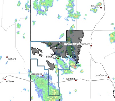
Increased moisture combined with a weak disturbance aloft will lead to an uptick in thunderstorm coverage across southern New Mexico today and Tuesday. Heavy rain rates and will lead to an increased risk of flash flooding, especially for burn scars, mountain canyons, and arroyos.
Southern Gila Region Highlands/Black Range-
Including the cities of Lake Roberts and Kingston
247 PM MDT Mon Jul 21 2025
...FLOOD WATCH IN EFFECT FROM TUESDAY AFTERNOON THROUGH TUESDAY
EVENING...
* WHAT...Flooding caused by excessive rainfall is possible.
HIGH WIND WEATHER ADVISORY:
High wind warning in Hidalgo County, visibility is low in areas due to blowing dust. High profile vehicles please use caution. The NMDOT will continue monitoring the roadway. This event will be updated as conditions change.
Page 10 of 168


WARNING: All articles and photos with a byline or photo credit are copyrighted to the author or photographer. You may not use any information found within the articles without asking permission AND giving attribution to the source. Photos can be requested and may incur a nominal fee for use personally or commercially.
Disclaimer: If you find errors in articles not written by the Beat team but sent to us from other content providers, please contact the writer, not the Beat. For example, obituaries are always provided by the funeral home or a family member. We can fix errors, but please give details on where the error is so we can find it. News releases from government and non-profit entities are posted generally without change, except for legal notices, which incur a small charge.
NOTE: If an article does not have a byline, it was written by someone not affiliated with the Beat and then sent to the Beat for posting.
Images: We have received complaints about large images blocking parts of other articles. If you encounter this problem, click on the title of the article you want to read and it will take you to that article's page, which shows only that article without any intruders.
New Columnists: The Beat continues to bring you new columnists. And check out the old faithfuls who continue to provide content.
Newsletter: If you opt in to the Join GCB Three Times Weekly Updates option above this to the right, you will be subscribed to email notifications with links to recently posted articles.
It has come to this editor's attention that people are sending information to the Grant County Beat Facebook page. Please be aware that the editor does not regularly monitor the page. If you have items you want to send to the editor, please send them to editor@grantcountybeat.com. Thanks!
Here for YOU: Consider the Beat your DAILY newspaper for up-to-date information about Grant County. It's at your fingertips! One Click to Local News. Thanks for your support for and your readership of Grant County's online news source—www.grantcountybeat.com
Feel free to notify editor@grantcountybeat.com if you notice any technical problems on the site. Your convenience is my desire for the Beat. The Beat totally appreciates its readers and subscribers!
Compliance: Because you are an esteemed member of The Grant County Beat readership, be assured that we at the Beat continue to do everything we can to be in full compliance with GDPR and pertinent US law, so that the information you have chosen to give to us cannot be compromised.
Those new to providing news releases to the Beat are asked to please check out submission guidelines at https://www.grantcountybeat.com/about/submissions. They are for your information to make life easier on the readers, as well as for the editor.
Advertising: Don't forget to tell advertisers that you saw their ads on the Beat.
Classifieds: We have changed Classifieds to a simpler option. Check periodically to see if any new ones have popped up. Send your information to editor@grantcountybeat.com and we will post it as soon as we can. Instructions and prices are on the page.