BC Comic for January 14, 2026
BY: Mason Mastroianni, Mick Mastroianni and Johnny Hart
 Click to Search
[{{{type}}}] {{{reason}}}
{{/data.error.root_cause}}
{{{_source.displayDate}}}
{{/_source.showDate}}{{{_source.description}}}
{{#_source.additionalInfo}}{{#_source.additionalFields}} {{#title}} {{{label}}}: {{{title}}} {{/title}} {{/_source.additionalFields}}
{{/_source.additionalInfo}}
You'll receive the Update on Monday, Wednesday, and Friday.

Conservation Organizations Outline Concerns with Ivanhoe Electric Mining Exploration Plans in the Pinos Altos Area, Gila National Forest
Silver City, NM -- Local and statewide conservation and community organizations submitted a letter to the Gila National Forest District Ranger outlining concerns with a massive new mining exploration project on the Gila National Forest being developed by Ivanhoe Electric, a U.S.-based mineral exploration company. In 2024, the company staked 642 lode claims covering 13,264 acres of Forest Service, Bureau of Land Management (BLM) and private land encircling the community of Pinos Altos, located 8 miles north of Silver City and considered the "gateway" to the Gila National Forest and Gila Wilderness. Exploration activities could impact the forest's natural resources and wildlife, recreational opportunities, property values of homes located adjacent to the Gila National Forest, and the local economy.
By Roger Lanse
Russell Dobkins, 75, of Gila, was booked into the Grant County Detention Center by Grant County Sheriff’s Office deputies on Dec. 28, 2025, charged with first degree murder and tampering with evidence in the Dec. 26, 2025, death of Esker Mayberry, 63, also of Gila.
On Monday, Jan. 12, 2026, Dobkins was ordered held in pretrial detention at the GCDC by Judge Jim Foy. Dobkins’ trial date is pending according to 6th Judicial District Court staff.
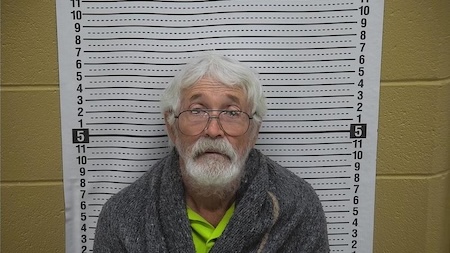
January 13, 2026 — Sixth Judicial District Attorney Norman R. Wheeler announced today that 75-year-old Russell Dobkins has been ordered held without bond after being charged with First-Degree Murder and Tampering with Evidence in connection with the death of Esker Roland Mayberry on December 26, 2025. Chief Deputy District Attorney Joseph Silva represented the State during the detention hearing before the Honorable Judge James Foy of the Sixth Judicial District Court. Dobkins remains in custody at this time.
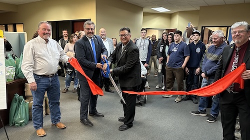 NM State Rep. Luis Terrazas and Sen. Gabriel Ramos cut the ribbon as their aides, Brett Kasten, on the left, and Bruce Ashburn, on the right, hold the ribbon.
Photo by Mary Alice Murphy
On Friday evening, Jan. 9, 2026, New Mexico Sen. Gabriel Ramos and Rep. Luis Terrazas welcomed an estimated 60-70 people who came to an open house and ribbon cutting, at their new local offices in the back of First American Bank at 1609 N. Swan St in Silver City. The senator and representative also requested a donation of a non-perishable food item for the town warming center, now renamed The Haven because of a copyright dispute. The estimate of the cost of the food donated was $650 plus cash donations $of 450, which the Ramos and Terrazas have agreed to match, all for The Haven.
NM 35 northbound and southbound from mile marker 11, 11 miles north of NM 152 to mile marker 27, 0.5 miles south of NM 15, is clear and removed from NMRoads.
ROAD ADVISORY
DIFFICULT DRIVING CONDITIONS: Silver City Area
Difficult Driving Conditions, NM 15 northbound and southbound from mile marker 6, 1 mile south of Pinos Altos to mile marker 25, 14 miles south of Gila Hot Springs, roads are icy in spots. Please drive with caution, reduce speed, and obey all posted traffic signs. The NMDOT will continue to monitor roadways. This event will be updated as conditions change.
DIFFICULT DRIVING CONDITIONS: Silver City Area
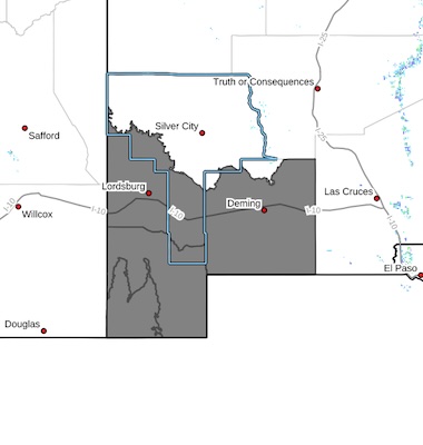 Southwest Desert/Lower Gila River Valley-Lowlands of the Bootheel-
Uplands of the Bootheel-Southwest Desert/Mimbres Basin-
Including the cities of Antelope Wells, Columbus, Red Rock,
Hachita, Cloverdale, Deming, Virden, Lordsburg, and Animas
1023 AM MST Sat Jan 10 2026
...COLD WEATHER ADVISORY IN EFFECT FROM 11 PM THIS EVENING TO 9 AM MST SUNDAY..
* WHAT...Very cold wind chills of 10 to 15 degrees expected.
* WHERE...Far Southwest New Mexico.
* WHEN...From 11 PM this evening to 9 AM MST Sunday.
* IMPACTS...Frostbite and hypothermia will occur if unprotected skin
is exposed to these temperatures.
Page 1 of 132


WARNING: All articles and photos with a byline or photo credit are copyrighted to the author or photographer. You may not use any information found within the articles without asking permission AND giving attribution to the source. Photos can be requested and may incur a nominal fee for use personally or commercially.
Disclaimer: If you find errors in articles not written by the Beat team but sent to us from other content providers, please contact the writer, not the Beat. For example, obituaries are always provided by the funeral home or a family member. We can fix errors, but please give details on where the error is so we can find it. News releases from government and non-profit entities are posted generally without change, except for legal notices, which incur a small charge.
NOTE: If an article does not have a byline, it was written by someone not affiliated with the Beat and then sent to the Beat for posting.
Images: We have received complaints about large images blocking parts of other articles. If you encounter this problem, click on the title of the article you want to read and it will take you to that article's page, which shows only that article without any intruders.
New Columnists: The Beat continues to bring you new columnists. And check out the old faithfuls who continue to provide content.
Newsletter: If you opt in to the Join GCB Three Times Weekly Updates option above this to the right, you will be subscribed to email notifications with links to recently posted articles.
It has come to this editor's attention that people are sending information to the Grant County Beat Facebook page. Please be aware that the editor does not regularly monitor the page. If you have items you want to send to the editor, please send them to editor@grantcountybeat.com. Thanks!
Here for YOU: Consider the Beat your DAILY newspaper for up-to-date information about Grant County. It's at your fingertips! One Click to Local News. Thanks for your support for and your readership of Grant County's online news source—www.grantcountybeat.com
Feel free to notify editor@grantcountybeat.com if you notice any technical problems on the site. Your convenience is my desire for the Beat. The Beat totally appreciates its readers and subscribers!
Compliance: Because you are an esteemed member of The Grant County Beat readership, be assured that we at the Beat continue to do everything we can to be in full compliance with GDPR and pertinent US law, so that the information you have chosen to give to us cannot be compromised.
Those new to providing news releases to the Beat are asked to please check out submission guidelines at https://www.grantcountybeat.com/about/submissions. They are for your information to make life easier on the readers, as well as for the editor.
Advertising: Don't forget to tell advertisers that you saw their ads on the Beat.
Classifieds: We have changed Classifieds to a simpler option. Check periodically to see if any new ones have popped up. Send your information to editor@grantcountybeat.com and we will post it as soon as we can. Instructions and prices are on the page.