

 Click to Search
Search
[{{{type}}}] {{{reason}}}
{{/data.error.root_cause}}
{{{_source.title}}} {{#_source.showPrice}} {{{_source.displayPrice}}} {{/_source.showPrice}}
{{#_source.showLink}} {{/_source.showLink}} {{#_source.showDate}}{{{_source.displayDate}}}
{{/_source.showDate}}{{{_source.description}}}
{{#_source.additionalInfo}}{{#_source.additionalFields}} {{#title}} {{{label}}}: {{{title}}} {{/title}} {{/_source.additionalFields}}
{{/_source.additionalInfo}}
Weather
- Category: Weather
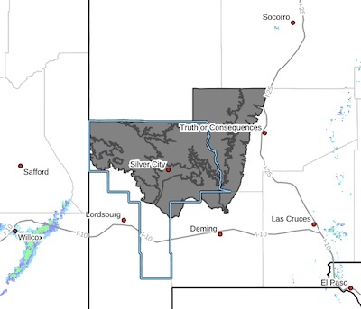
The flash flood warning is primarily over the Trout Burn scar. If you live there, you know where it is.
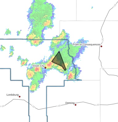 Flash Flood Warning
National Weather Service El Paso Tx/Santa Teresa NM
449 PM MDT Thu Jul 31 2025
The National Weather Service in El Paso Tx/Santa Teresa has issued a
* Flash Flood Warning for...
The Trout Fire Burn Scar in...
Northeastern Grant County in southwestern New Mexico...
* Until 700 PM MDT.
- Category: Weather
HIGH WIND WEATHER ADVISORY:
High wind warning in Hildago County, visibility is low in areas due to blowing dust. High profile vehicles please use caution. The NMDOT will continue monitoring the roadway. This event will be updated as conditions change
[Editor's Note: Since this happens almost every day, do we still need to post this? How about just being prepared for high wind and low visibility almost every afternoon!]
- Category: Weather
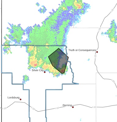
 FLOOD ADVISORY IN EFFECT UNTIL 1030 PM MDT THIS EVENING...
* WHAT...Arroyo and small stream flooding caused by excessive
rainfall is expected.
* WHERE...A portion of southwest New Mexico, including the following county, Grant.
* WHEN...Until 1030 PM MDT.
* IMPACTS...Minor flooding in low-lying and poor drainage areas.
* ADDITIONAL DETAILS...
- At 721 PM MDT, Doppler radar indicated heavy rain due to
thunderstorms. This will cause arroyo and small stream flooding. Up to 1 inch of rain has fallen.
- Category: Weather
FLOODING – Deming/Columbus Area
Difficult Driving Conditions, NM 9 eastbound and westbound at mile marker 93, 4 miles east of Columbus. Standing water on roadway. Use extreme caution.
When the roadway is flooded do not cross and seek an alternate route. Turn around, don’t drown.
- Category: Weather
 Abundant moisture across the region will combine with a weak upper level storm system and rain from last night has saturated the ground, all of this will give us an enhanced risk of flash flooding today through early Wednesday morning. Any thunderstorms that develop today and tonight will be very efficient rain makers. Isolated rainfall amounts of 2 to 3 inches of rain will be possible which will lead to flash flooding.
Upper Gila River Valley-Southern Gila Foothills/Mimbres Valley-Southwest Desert/Mimbres Basin-Eastern Black Range Foothills-Sierra County Lakes-Northern Dona Ana County-Southern Dona Ana County/Mesilla Valley-West Slopes Sacramento Mountains Below
- Category: Weather
[Editor's Note: Hey, readers, the wind is blowing. Be careful on the roads. Please email me at
HIGH WIND WEATHER ADVISORY:
High wind warning in Luna County, visibility is low in areas due to blowing dust. High profile vehicles please use caution. The NMDOT will continue monitoring the roadway. This event will be updated as conditions change.
HIGH WIND WEATHER ADVISORY:
High wind warning in Hildago County, visibility is low in areas due to blowing dust. High profile vehicles please use caution. The NMDOT will continue monitoring the roadway. This event will be updated as conditions change
HIGH WIND WEATHER ADVISORY:
High wind warning in Hatch/ Rincon areas of Dona Ana County, visibility is low in areas due to blowing dust. High profile vehicles please use caution. The NMDOT will continue monitoring the roadway. This event will be updated as conditions change
- Category: Weather
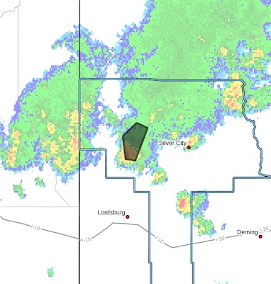
The National Weather Service in El Paso Tx/Santa Teresa has issued a
* Flash Flood Warning for...
Northeastern Grant County in southwestern New Mexico...
* Until 415 PM MDT.
* At 151 PM MDT, Doppler radar indicated thunderstorms producing heavy rain across the warned area. Between 1.5 and 2 inches of
rain have fallen. Additional rainfall amounts of 0.5 to 1.5 inches are possible in the warned area. Flash flooding is ongoing or expected to begin shortly.
HAZARD...Flash flooding caused by thunderstorms.
SOURCE...Radar.
- Category: Weather
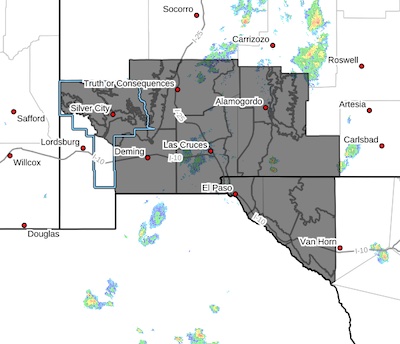
 Upper Gila River Valley-Southern Gila Foothills/Mimbres Valley- Eastern Black Range Foothills-Central Grant County/Silver City
Area-Southern Gila Region Highlands/Black Range- Including the cities of Grant County Airport, Cliff, Faywood, Mimbres, Kingston, Lake Roberts, Winston, Silver City, Hillsboro, Fort Bayard, Buckhorn, Gila Hot Springs, Hurley, and Mule Creek
516 AM MDT Mon Jul 28 2025
...FLOOD WATCH IN EFFECT FROM NOON MDT TODAY THROUGH THIS EVENING...
* WHAT...Flooding caused by excessive rainfall is possible.


Content on the Beat
WARNING: All articles and photos with a byline or photo credit are copyrighted to the author or photographer. You may not use any information found within the articles without asking permission AND giving attribution to the source. Photos can be requested and may incur a nominal fee for use personally or commercially.
Disclaimer: If you find errors in articles not written by the Beat team but sent to us from other content providers, please contact the writer, not the Beat. For example, obituaries are always provided by the funeral home or a family member. We can fix errors, but please give details on where the error is so we can find it. News releases from government and non-profit entities are posted generally without change, except for legal notices, which incur a small charge.
NOTE: If an article does not have a byline, it was written by someone not affiliated with the Beat and then sent to the Beat for posting.
Images: We have received complaints about large images blocking parts of other articles. If you encounter this problem, click on the title of the article you want to read and it will take you to that article's page, which shows only that article without any intruders.
New Columnists: The Beat continues to bring you new columnists. And check out the old faithfuls who continue to provide content.
Newsletter: If you opt in to the Join GCB Three Times Weekly Updates option above this to the right, you will be subscribed to email notifications with links to recently posted articles.
Editor's Notes
It has come to this editor's attention that people are sending information to the Grant County Beat Facebook page. Please be aware that the editor does not regularly monitor the page. If you have items you want to send to the editor, please send them to editor@grantcountybeat.com. Thanks!
Here for YOU: Consider the Beat your DAILY newspaper for up-to-date information about Grant County. It's at your fingertips! One Click to Local News. Thanks for your support for and your readership of Grant County's online news source—www.grantcountybeat.com
Feel free to notify editor@grantcountybeat.com if you notice any technical problems on the site. Your convenience is my desire for the Beat. The Beat totally appreciates its readers and subscribers!
Compliance: Because you are an esteemed member of The Grant County Beat readership, be assured that we at the Beat continue to do everything we can to be in full compliance with GDPR and pertinent US law, so that the information you have chosen to give to us cannot be compromised.
Submitting to the Beat
Those new to providing news releases to the Beat are asked to please check out submission guidelines at https://www.grantcountybeat.com/about/submissions. They are for your information to make life easier on the readers, as well as for the editor.
Advertising: Don't forget to tell advertisers that you saw their ads on the Beat.
Classifieds: We have changed Classifieds to a simpler option. Check periodically to see if any new ones have popped up. Send your information to editor@grantcountybeat.com and we will post it as soon as we can. Instructions and prices are on the page.