

 Click to Search
Search
[{{{type}}}] {{{reason}}}
{{/data.error.root_cause}}
{{{_source.title}}} {{#_source.showPrice}} {{{_source.displayPrice}}} {{/_source.showPrice}}
{{#_source.showLink}} {{/_source.showLink}} {{#_source.showDate}}{{{_source.displayDate}}}
{{/_source.showDate}}{{{_source.description}}}
{{#_source.additionalInfo}}{{#_source.additionalFields}} {{#title}} {{{label}}}: {{{title}}} {{/title}} {{/_source.additionalFields}}
{{/_source.additionalInfo}}
Weather
- Category: Weather
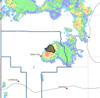
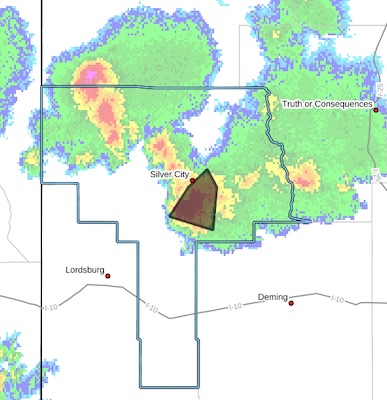 FLOOD ADVISORY IN EFFECT UNTIL 715 PM MDT THIS EVENING...
* WHAT...Arroyo and small stream flooding caused by excessive rainfall is expected.
* WHERE...A portion of southwest New Mexico, including the following county, Grant.
* WHEN...Until 715 PM MDT.
* IMPACTS...Rises in small streams and normally dry arroyos.
* ADDITIONAL DETAILS...
- At 401 PM MDT, Doppler radar indicated heavy rain due to thunderstorms. This will cause arroyo and small stream flooding. Between 1 and 1.5 inches of rain have fallen.
- Category: Weather
 Southwest Desert/Lower Gila River Valley NM-
Upper Gila River Valley NM-
Southern Gila Region Highlands/Black Range NM-
254 PM MDT Sun Aug 10 2025
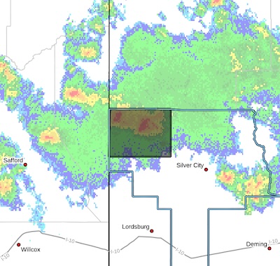
...A STRONG THUNDERSTORM WILL IMPACT NORTHWESTERN GRANT COUNTY THROUGH 400 PM MDT...
At 253 PM MDT, Doppler radar was tracking several strong
thunderstorms in northwest Grant county, moving southeast at 20 mph.
HAZARD...Wind gusts up to 50 mph and half inch hail.
SOURCE...Radar indicated.
- Category: Weather
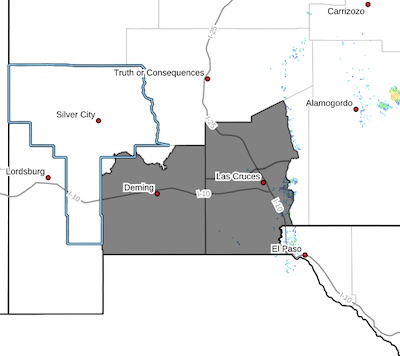
* WHAT...Afternoon maximum temperatures at or above 105.
* WHERE...Lowlands of the Bootheel, Southwest Desert/Lower Gila
River Valley, and Upper Gila River Valley.
* WHEN...Until 9 PM MDT Wednesday.
- Category: Weather
 Southwest Desert/Mimbres Basin-Northern Dona Ana County-Southern
Dona Ana County/Mesilla Valley-
Including the cities of Sunland Park, Las Cruces, Radium Springs,
Hatch, Columbus, Vado, Deming, and Garfield
1107 AM MDT Mon Aug 4 2025
...HEAT ADVISORY IN EFFECT UNTIL 9 PM MDT WEDNESDAY...
* WHAT...Temperatures at or above 105 expected.
* WHERE...Northern Dona Ana County, Southern Dona Ana County/Mesilla
Valley, and Southwest Desert/Mimbres Basin.
* WHEN...Until 9 PM MDT Wednesday.
- Category: Weather
Severe Thunderstorm Warning
National Weather Service El Paso TX
350 PM MDT Sat Aug 2 2025
The National Weather Service in El Paso has issued a
 * Severe Thunderstorm Warning for...
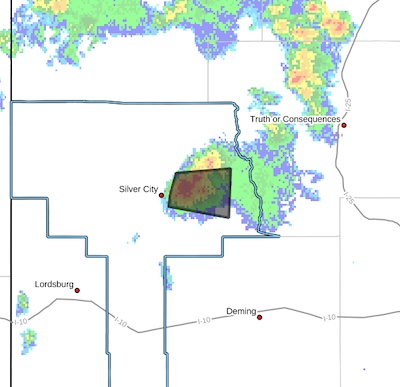
East central Grant County in southwestern New Mexico...
* Until 445 PM MDT.
* At 349 PM MDT, a severe thunderstorm was located near Hanover, moving east at 20 mph.
HAZARD...60 mph wind gusts and quarter size hail.
SOURCE...Radar indicated.
IMPACT...Hail damage to vehicles is expected. Expect wind damage to roofs, siding, and trees.
* Locations impacted include...
San Lorenzo, Cobre, Bayard, Sherman, Hanover, San Juan, Fierro, Mimbres, North Hurley, Santa Clara, Fort Bayard, Georgetown, Arenas Valley, and Bear Canyon Lake.
PRECAUTIONARY/PREPAREDNESS ACTIONS...
- Category: Weather
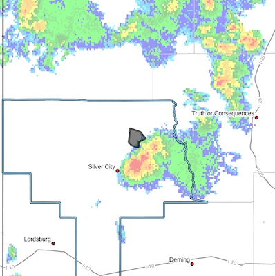
 Flash Flood Warning
National Weather Service El Paso Tx/Santa Teresa NM
248 PM MDT Sat Aug 2 2025
The National Weather Service in El Paso Tx/Santa Teresa has issued a
* Flash Flood Warning for...The Trout Fire Burn Scar in... North Central Grant County in southwestern New Mexico...
* Until 500 PM MDT.
* At 248 PM MDT, Doppler radar indicated thunderstorms producing heavy rain over the Trout Fire Burn Scar. Between 0.1 and 0.4
inches of rain have fallen. Additional rainfall amounts up to 0.5 inches are possible in the warned area. Flash flooding is ongoing or expected to begin shortly.
- Category: Weather
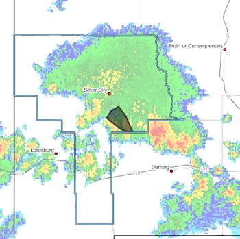
 Flash Flood Warning for...
The Trout Fire Burn Scar in...
North Central Grant County in southwestern New Mexico...
* Until 430 PM MDT.
* At 227 PM MDT, Doppler radar indicated thunderstorms producing
heavy rain over the Trout Fire Burn Scar. Between 0.3 and 0.6 inches of rain have fallen. Additional rainfall amounts up to 1 inch are possible in the warned area. Flash flooding is ongoing or
expected to begin shortly.
Excessive rainfall over the burn scar will result in debris flow moving through the Trout Fire Burn Scar, into canyons flowing north towards Sapillo Creek ABOVE Lake Roberts Dam, including Hill Canyon and Skates Canyon. Sapillo Creek UPSTREAM...or EAST of Lake Roberts Dam will also be impacted. The debris flow can consist of rock, mud, vegetation and other loose materials.
- Category: Weather
 Flash Flood Warning
National Weather Service El Paso Tx/Santa Teresa NM
721 PM MDT Thu Jul 31 2025
The National Weather Service in El Paso Tx/Santa Teresa has issued a
* Flash Flood Warning for...
Central Grant County in southwestern New Mexico...
* Until 915 PM MDT.
* At 721 PM MDT, Doppler radar indicated thunderstorms producing heavy rain across the warned area. Between 1 and 2 inches of rain have fallen. Additional rainfall amounts up to 1 inch are possible
in the warned area. Flash flooding is ongoing or expected to begin shortly.

Western Bank holiday hours 2025


Content on the Beat
WARNING: All articles and photos with a byline or photo credit are copyrighted to the author or photographer. You may not use any information found within the articles without asking permission AND giving attribution to the source. Photos can be requested and may incur a nominal fee for use personally or commercially.
Disclaimer: If you find errors in articles not written by the Beat team but sent to us from other content providers, please contact the writer, not the Beat. For example, obituaries are always provided by the funeral home or a family member. We can fix errors, but please give details on where the error is so we can find it. News releases from government and non-profit entities are posted generally without change, except for legal notices, which incur a small charge.
NOTE: If an article does not have a byline, it was written by someone not affiliated with the Beat and then sent to the Beat for posting.
Images: We have received complaints about large images blocking parts of other articles. If you encounter this problem, click on the title of the article you want to read and it will take you to that article's page, which shows only that article without any intruders.
New Columnists: The Beat continues to bring you new columnists. And check out the old faithfuls who continue to provide content.
Newsletter: If you opt in to the Join GCB Three Times Weekly Updates option above this to the right, you will be subscribed to email notifications with links to recently posted articles.
Editor's Notes
It has come to this editor's attention that people are sending information to the Grant County Beat Facebook page. Please be aware that the editor does not regularly monitor the page. If you have items you want to send to the editor, please send them to editor@grantcountybeat.com. Thanks!
Here for YOU: Consider the Beat your DAILY newspaper for up-to-date information about Grant County. It's at your fingertips! One Click to Local News. Thanks for your support for and your readership of Grant County's online news source—www.grantcountybeat.com
Feel free to notify editor@grantcountybeat.com if you notice any technical problems on the site. Your convenience is my desire for the Beat. The Beat totally appreciates its readers and subscribers!
Compliance: Because you are an esteemed member of The Grant County Beat readership, be assured that we at the Beat continue to do everything we can to be in full compliance with GDPR and pertinent US law, so that the information you have chosen to give to us cannot be compromised.
Submitting to the Beat
Those new to providing news releases to the Beat are asked to please check out submission guidelines at https://www.grantcountybeat.com/about/submissions. They are for your information to make life easier on the readers, as well as for the editor.
Advertising: Don't forget to tell advertisers that you saw their ads on the Beat.
Classifieds: We have changed Classifieds to a simpler option. Check periodically to see if any new ones have popped up. Send your information to editor@grantcountybeat.com and we will post it as soon as we can. Instructions and prices are on the page.